-
Title
-
Eng
Examining the Ship Strike Risk of Humpaback Whales in Northern Washington State
-
Date
-
2014
-
Creator
-
Eng
Stendahl, Rachel
-
Subject
-
Eng
Environmental Studies
-
extracted text
-
EXAMINING THE SHIP STRIKE RISK OF HUMPBACK WHALES IN
NORTHERN WASHINGTON STATE
By
Rachel Stendahl
A Thesis
Submitted in partial fulfillment
of the requirements for the degree
Master ofEnvironmental Studies
The Evergreen State College
August 2014
��This Thesis for the Master of Environmental Studies Degree
by
Rachel Stendahl
has been approved for
The Evergreen State College
By
/
'(·~., t'i_
Date
I
�ABSTRACT
Examining the ship strike risk of humpback whales in northern Washington State
Rachel Stendahl
The Olympic Coast National Marine Sanctuary and the surrounding waters of
Washington State are important habitats for humpback whales (Megapotera
noveangeliae). Ship strike mortality in the area is poorly understood. Comparison
of cargo and tanker vessel tracks from Satellite Automatic Identification data and
the locations of humpback whale sightings using sighting data gathered from
Cascadia Research Collective and the Olympic Coast National Marine Sanctuary
during NOAA ship surveys during the years 1995-2008 were used to examine
humpback whale ship strike risk in the region. Spatial analyses showed the
highest probability of a whale-vessel collisions occurred in areas with the highest
amount of vessel traffic. The results of this study suggest that there are specific
hotpots for whale and vessel encounters within this region which could indicate
that there are potential viable mitigation techniques including rerouting the
current shipping lanes to minimize encounters, reducing vessel speeds in the area
and narrowing the shipping lanes. An interdisciplinary approach was used to look
at this issue. To add depth and understanding, a literature review was compiled
illustrating which species of whales are commonly hit by ships and what part of
their life history makes them more vulnerable, gives background on the difficulty
of compiling the actual whale mortality rates from ship strikes, case studies and
potential mitigation procedures. In addition, there are three chapters of extended
discussion that focus on the costs associated with this issue, collaborative
management of the sanctuary and future directions and limitations to this study.
�Acknowledgements
I would like to thank my reader Dr. Carri LeRoy for all of her support and guidance
during this project. I would also like to thank my collaborators at Cascadia Research
Collective, notably John Calambokidis for providing me with whale sighting data and
sharing his expertise on marine mammals with me, as well as Annie Douglas and Glenn
Gailey for their practical data interpretation, and analysis help. Thanks to the staff at the
Olympic Coast National Marine Sanctuary, especially Nancy Wright, for providing me
with the shipping data.
On a personal note, thanks to all my family and friends. Special thanks to my parents, my
brothers, Robert Coleman, Kwasi Addae, Jennifer Dunn, Brianna Momingred and Molly
Sullivan.
I would like dedicate this thesis in memory of Dion Jamieson
�Table of Contents
List of Figures .................................................................................................................. viii
List of Tables ..................................................................................................................... ix
List of Common Abbreviations .......................................................................................... x
Chapter 1: Literature Review .............................................................................................. 1
Introduction ..................................................................................................................... 1
Species Commonly Involved in Collisions with Ships ................................................... 3
Fin Whales ................................................................................................................... 3
North Atlantic Right Whales ....................................................................................... 4
Sperm Whales .............................................................................................................. 5
Blue Whales ................................................................................................................. 6
Gray Whales ................................................................................................................ 6
Humpback Whales ....................................................................................................... 7
Humpback Whale Data Collection and Abundance Estimation Techniques .................. 8
Stranding Response and Difficulty Reporting Data ........................................................ 9
Non-fatal Impacts ofVessel Traffic on Whales ............................................................ 10
History of Shipping Traffic in Washington .................................................................. 13
Vessel Lanes and the Ports of Washington State .......................................................... 13
The History of Humpback Whales in Washington ....................................................... 14
Olympic National Marine Sanctuary ............................................................................. 15
Current Mitigation Procedures ...................................................................................... 16
Case Studies .................................................................................................................. 18
East Coast of the U.S.- Right Whales ....................................................................... 18
Southern California- Blue Whales ............................................................................. 20
Future Research Needs .................................................................................................. 22
Conclusion ..................................................................................................................... 23
Chapter 2 Manuscript ........................................................................................................ 24
Abstract ......................................................................................................................... 24
Introduction ................................................................................................................... 24
Study Area ..................................................................................................................... 26
v
�Methods ....................... :................................................................................................. 26
Sources of Data ............................................................................................................. 28
Mapping and Spatial Analysis ....................................................................................... 32
Results ........................................................................................................................... 36
Calculating Encounter Rates ............................................................................................. 41
Relative Probability of Observing a Whale or Vessel... ................................................ 42
Relative Probability of a Whale and Vessel Encounter ................................................ 44
Non-effort corrected Relative Probabilities .................................................................. 44
Discussion ..................................................................................................................... 46
Significance of This Study ............................................................................................ 48
Potential Mitigation Options ......................................................................................... 48
Conclusion ..................................................................................................................... 50
Chapter 3- Collaborative Management of the Sanctuary .................................................. 51
Introduction ................................................................................................................... 51
Marine Protected Areas ................................................................................................. 51
The Effectiveness of the Sanctuary ............................................................................... 52
Formal Collaborative Bodies ........................................................................................ 56
Conclusion ..................................................................................................................... 57
Chapter 4-Costs ................................................................................................................. 58
Introduction ................................................................................................................... 58
Economic Costs ............................................................................................................. 58
Injuries and Costs to Humans from Ship Strikes .......................................................... 59
Animal Welfare Perspective .......................................................................................... 60
Conclusion ..................................................................................................................... 61
Chapter 5: Future Directions/Limitations to this Study .................................................... 62
Introduction ................................................................................................................... 62
Other Conservation Concerns in the Sanctuary ............................................................ 66
Future Uses for These Data ........................................................................................... 68
Conclusion ..................................................................................................................... 68
Appendix ........................................................................................................................... 70
Works Cited ...................................................................................................................... 75
VI
�List of Figures
Figure 1. The 14 main theoretical transect lines traveled during the surveys ........ 29
Figure 2. The number of"on-effort" humpback whales sighted from the 14
main transects in the OCNMS during the years 1995-2002 .................................. 35
Figure 3. Bivariate fit of whales per grid by vessel distance traveled ................... 37
Figure 4. Histogram of number of whales per sighting ......................................... 38
Figure 5. Map of the number of individual humpback whales per sighting .......... 39
Figure 6. Heat map of combined vessel traffic and whale sighting locations ..... .40
Figure 7. The relative probability of an encounter between a whale and a ship ... .43
Figure 8. The non-effort corrected relative probability of an encounter between
a whale and a ship .................................................................................................. 45
Figure 9. The sighting locations of all humpback whales seen during survey
efforts 1995-2008 ................................................................................................... 47
Figure 10. Map of the OCNMS area to be avoided ............................................... 54
Figure 11. Cargo ship usage ofthe Washington outer coast in 2013 .................... 72
Figure 12. Tanker ship usage of the Washington outer coast in 2013 ................... 73
V111
�List of Tables
Table 1. Summary of Humpback Sightings by Year During Ship Surveys Off
Northern Washington ............................................................................................. 31
Table 2. Summary of Humpback Sighting Effort .................................................. 64
Table 3. Summary of Vessel Traffic and Type ...................................................... 70
ix
�List of Common Abbreviations
ATBA
Areas To Be Avoided
CSCAPE
Collaborative Survey of Cetacean Abundance and Pelagic
Ecosystems
GIS
Geographic Information System
IPC
Intergovernmental Policy Council
IWC
International Whaling Commission
NMS
National Marine Sanctuaries
NOAA
National Oceanographic and Atmospheric Association
OCNMS
Olympic Coast National Marine Sanctuary
SAC
Sanctuary Advisory Council
S-AIS
Satellite Automatic Identification System
SPUE
Sightings Per Unit Effort
TSS
Traffic Separation Scheme
WINCRUZ
Windows Real Time Sighting-Effort Event Logger
X
�Chapter 1: Literature Review
Introduction
Collisions with ships are a major cause of mortality for many whales throughout
the world (Wiley et al., 2011, Laist et al., 2001 ). Many of the cetacean species involved
in collisions with vessels are endangered. Eleven species of large whales have been
documented as having evidence of ship strikes (Laist et al., 2001 ). These include: fin
whales (Balaenoptera physalis), North Atlantic right whales (Eubalaena glacialis),
sperm whales (Physeter macrocephalus), blue whales (Balaenoptera musculus), gray
whales (Eschrichitus robustus) and humpback whales (Megaptera novaeangliae).
Perhaps the most well-known species involved in collisions with ships is the North
Atlantic right whale which has received considerable publicity because it is estimated
there are fewer than 350 individuals of this species left in the world (Vanderlaan &
Taggart, 2009). In this literature review I will further describe each of these species and
their specific vulnerabilities to ship strikes.
Some species of whales are more likely to be involved in collisions with ships
because of their life history traits. These life history traits include; their feeding styles,
calving locations, diving biology and resting behaviors, and most importantly, their
feeding locations. Whales that swim slowly and are at the surface often are especially
vulnerable to ship strikes. For each species I will describe each trait and how it influences
altercations with ships, which have been increasing in recent years.
Not all interactions between ships and whales are fatal. Humpback whales can
also experience both behavioral and physical changes due to constant exposure to ships.
Anthropogenic underwater noise can cause stress responses, habitat avoidance and other
�detrimental but non-fatal changes. In addition, understanding the numbers of whales
struck by ships in an area is very complex. Many factors influence the number of species
of whales struck by ships every year. These factors include non-uniform data collection
and stranding response and the location of the whales when they were struck by the ship
(Douglas et al., 2008). Each of these factors will be further explored.
Levels of oceanic shipping have increased greatly in the last 60 years and will
continue to grow into the foreseeable future. Faster ships are more likely to be involved
in lethal collisions with whales and there are several areas of overlap with both high
densities of whales and shipping traffic, notably: the northern Mediterranean Sea, the
East Coast of the U.S, the Strait of Gibraltar and the Canary Islands, and the West Coast
of the U.S., which are all hotspots for altercations between whales and ships (Carillo &
Ritter, 2010, Calambokidis, 2011 ). In this literature review I will focus on ship strikes of
whales in the United States.
Several ship strike mitigation procedures have already been implemented in
attempts to preserve vulnerable populations and species of whales; however, many of
these mitigation procedures have not proven to be very effective. The most effective
method of diminishing whale and vessel collisions is minimizing the area of overlap
between ship traffic lanes and whale populations (Williams & O'Hara, 2009). This is
achieved through areas to be avoided (ABTA) and traffic separation schemes (TSS) in
areas ofhigh whale densities. These methods have been demonstrated in two case
studies, one in the Santa Barbara Channel off the coast of southern California (BermanKowalewski et al., 201 0) and in critical right whale habitat off the East Coast of the U.S
2
�(Mullen, Peterson & Todd, 2013). Here I will use these two Case Studies to describe the
methods and results of previous research.
Ship strikes are a growing concern in the waterways of Washington State. There
have been numerous recorded ship strikes in the last several years. Whales showing signs
of ship strike-caused mortalities have washed ashore in Burien, Long Beach, Whidbey
Island and Ocean City, among others (Cascadia Stranding Response and Unusual
Sightings, 2013). The Strait of Juan de Fuca and the Olympic Coast National Marine
Sanctuary (OCNMS) are particular hotspots for whale and ship interactions in the region
because ofthe high vessel traffic in these areas. These areas are frequented by several
species of large whales, but the seasonal humpback whale populations are of particular
interest because of their unique life history traits and because they are members of a
distinct subpopulation that potentially requires extra protection measures (Calambokidis
et al., 2008). In this literature review, I will further elaborate on the unique situation of
humpback whales and ship interactions in the waters of Washington State.
Examining humpback whale population densities in the waters of Washington
State compared to the vessel densities in those areas could aid our understanding of the
risks of humpback whales being struck by ships. This research could potentially provide
insight into better locations for the shipping lanes to be moved, in order to help conserve
this important species.
Species Commonly Involved in Collisions with Ships
Fin Whales
Fin whales are the most commonly reported species of whale being hit by ships
worldwide (Vanderlaan & Taggart, 2009). The fin whale is found in all oceans ofthe
3
�world ranging from tropical to Polar Regions and they are the second largest animal in
the world, smaller only than the blue whale. They are a long, streamlined species, so it is
likely that they are recorded as having the most altercations with ships because of their
propensity to get draped over the bow of ships and brought all the way into port (Laist et
a!. 2001). All seven fin whales that have stranded in Washington State since 2002 have
had collisions with ships as their recorded cause of death (Douglas eta!., 2008). Fin
whales are currently listed as an endangered species by the United States Endangered
Species Act. The migration patterns of fin whales are still poorly understood which
makes estimating a total population count for the species difficult, nevertheless,
worldwide populations of this species are currently estimated at 118,000 but are likely
less than 100,000 (Klinowska, 1991 ).
North Atlantic Right Whales
Ship strikes are an extremely important factor in the lack of recovery for the North
Atlantic right whale. These whales were hunted to near extinction in the 1800s and early
1900s. The current worldwide species population for North Atlantic right whales is
estimated at Jess than 400 individuals. Vessel-whale collisions are the cause of most of
the recorded deaths for this species. Collisions represented the ultimate cause of death for
21 (52.5%) of the 40 North Atlantic right necropsied between 1970 and December 2006
(Campbell-Malone et a!., 2008). Right whales are particularly buoyant, using their
positive buoyancy for more efficient swimming and diving. This buoyancy may impede
diving responses to oncoming vessels and their ability to maneuver during free ascents
(Nowacek et a!., 2001 ). Their buoyancy is one reason they are so commonly involved in
collisions with vessels. This species also inhabits one ofthe most urbanized coastal
4
�locations in the world, near the port of Boston, U.S.A (Vanderlaan & Taggart, 2009). One
study showed that decreasing mortality by just two females per year now and in the near
future, could be responsible for the survival of the species, so it is extremely important
that vessel-caused mortalities are minimized (Vanderlaan & Taggart, 2009).
Sperm Whales
Sperm whales are the largest of the toothed whales, with males averaging 15 m in length
(Whitehead, 2002). They primarily feed on colossal or giant squid. They have been
known to dive to depths of up to 2987 m searching for their prey and can remain
submerged for up to 90 minutes. Sperm whales were a big target of the whaling industry
in the late 1800s through the late 1890s because their heads contain a liquid wax called
spermaceti, which was historically used in lubricants, oil lamps, and candles (Whitehead,
2002). The sperm whale is found in all oceans of the world and females and juveniles live
together in small groups. They mostly reside in deep waters, but can also be found in
locations where the continental shelf drops off rapidly. It appears that some sperm whales
may fall into a deep sleep for about 7% of each 24-hour period, most often between 6
p.m. and midnight, and it is this behavior that likely places them at increased risk of
collisions with vessels (Panigada et al., 2006). Sperm whales are thought to have hihemispheric sleep which means that they switch off both sides of their brain rather than
the uni-hemispheric way that most whale species are thought to sleep. This apparent hihemispheric sleep is possibly causing them to be completely unresponsive to approaching
vessels (Carillo & Ritter, 20 I 0). The sperm whale is currently listed as vulnerable by the
International Union for the Conservation ofNature (IUCN) and endangered by the U.S.
Endangered Species Act (Taylor et al., 2008).
5
�Blue Whales
Ship strikes are an important source of mortality among blue whales. Blue whales offthe
coast ofCalifornia are particularly well-studied (Berman-Kowalewski et al., 2010). Blue
whales have four recognized subspecies and five potential subpopulations in the North
Pacific, but there is still some ambiguity about these distinctions (Berman-Kowalewski,
eta!., 201 0). Blue whales have been shown to spend almost twice as much time near the
surface at night compared to the day (Calmbokidis, 2011 ). They often feed at depths of
up to 300 meters during the day, but they tend to dive shallower in the evening. At night
they mostly do not feed and stay close to the surface. It was shown that these whales were
almost twice as likely to be in the surface zone and be susceptible to being hit by a vessel
during the night as during the day (Calambokidis, 20 II).
Gray Whales
There are currently two recognized populations of gray whale in the North Pacific.
Recent genetic studies have examined both nuclear and mitochondrial markers to
understand their differences. These studies have suggested that there are significant
differences between what is known as the western North Pacific (WNP) population and
the eastern North Pacific (ENP) population (LeDuc et al., 2002; Weller et al., 2012).
Most whales in the ENP migrate each spring from their calving lagoons in Baja, Mexico
to their feeding grounds in the Arctic. However, since the 1970's there has been
documented photographic evidence that some gray whales spend their spring, summer
and fall in the waters off the Washington Coast (Darling, 1984). In recent years, these
whales have been very well-studied to understand their status and numbers because of
their close proximity to the traditional hunting grounds of the Makah Tribe. Both
6
�populations were commercially hunted and greatly reduced; however, only the eastern
gray whale has returned to near pre-whaling numbers (Calambokidis et al., 2002).
Humpback Whales
Humpback whales are currently listed as a species of"least concern" by the IUCN
(Klinowska, 1991 ). However, this listing only takes into account their worldwide
population which is estimated at around 60,000 individuals. This estimate does not
consider the many distinct subpopulations of humpback whales, several of which are very
depleted and in need of increased protection. The North Pacific humpback population is
estimated at just over 20,000, with about 2,000 feeding offthe U.S. West Coast, and is
most likely still below pre-whaling numbers (Barlow et al., 2011 ). For management
purposes, the National Oceanographic and Atmospheric Association (NOAA) has
categorized humpback whales into three separate populations in the North Pacific. These
populations include: 1) the eastern North Pacific population which winters off the coast
ofMexico and summers offthe coast of California, Oregon and Washington; 2) the
central North Pacific population, which winters in the central North Pacific and the
Hawaiian Islands and summers in Alaska in Prince Williams Sound and British
Columbia; and 3) the western North Pacific population, which winters in the western
North Pacific, in the Bonin Islands, Ryukyu Islands, the Philippines, and possibly in other
island areas in the southwestern North Pacific and summers off Kamchatka Peninsula, in
the Bering Sea and along the Aleutian Islands, west of the Kodiak islands (Calambokidis
et al., 2001, 2008).
Humpback whales spend summers at their high-latitude feeding grounds and
winters at their low-latitude breeding grounds (Weinrich, 1998). When at their feeding
7
�grounds, humpback whales congregate around areas of high productivity and upwelling,
which are usually defined by the bottom topography and relief of the area. Within these
productive areas, whale distributions are correlated with the amount of locally available
prey items (Weinrich, 1998). The type and abundance of food varies by location and
season. Changes in prey availability, suddenly, or over time have been shown to affect
whale distributions as they shift their locations to find their preferred prey items
(Weinrich, 1998). Female humpback whales give birth to a single calf at their breeding
grounds, usually every one to four years. The offspring stay with their mothers for at least
nine months, and the calf is usually weaned late in their stay at their feeding grounds or
after they migrate back to their low-latitude breeding grounds. This gives the calf plenty
of experience migrating to both locations before leaving its mother's side (Weinrich,
1998).
Humpback Whale Data Collection and Abundance Estimation Techniques
Humpback whales are individually identified and catalogued as a method of tracking
individuals and understanding population dynamics. These whales are identified using
natural markings on the ventral side of their flukes in combination with capture-recapture
methods (often also called mark-recapture methods). The method of capture-recapture
has also been paired with genetic identification of individuals to gain a greater
understanding of the species' life history. Line transect methods have greatly advanced in
the last several decades and are a common tool used in humpback whale abundance
measurements (Barlow et al., 2011 ). Line transect methods have been shown to be
effective for measuring whale densities in several other studies, including baleen whales
in the North Pacific (Barlow, 1995, Kishiro et al., 1997), minke whale in the Antarctic
8
�(Buckland, 1987) and fin whales in the North Atlantic (Buckland et al., 1992). The exact
numbers of humpback whales returning to Washington State are becoming clearer
because of these effective abundance estimation techniques; however, there is still
considerable uncertainty surrounding the exact numbers of this species being hit by ships
each year.
Stranding Response and Difficulty Reporting Data
It is likely that many vessel strikes on cetaceans go undetected or unreported. Even when
a carcass arrives onshore and is able to be necropsied, it is not always possible to tell if a
ship strike was involved in the death. This is often because the carcass is in an advanced
state of decomposition or because there were no outward signs of a vessel strike (Silber et
al., 20 12). In addition, cetaceans are often struck far from shore and their bodies are
likely lost at sea. Many whales are neutrally or negatively buoyant and as such are likely
to sink to the ocean floor instead of floating ashore. It is also possible that some
uncertainty in the number of whales struck and killed by vessels is because it is not
always easy to tell if the whale was already dead when it was struck by a ship. Whales
are more likely to be hit ventrally if previously dead upon impact, because whales usually
float belly up, but this is not always the case (Jensen & Silber, 2003).
Formal stranding networks were first formed in the 1980's, under the guidance of
the National Marine Fisheries Service Marine Mammal Health and Stranding Response
Program (Norman et al., 2004 ). Stranding response groups are composed of state and
federal wildlife and fisheries agencies, veterinary clinics, university and private
researchers, enforcement agencies and volunteers. Detailed stranding documentation is
attempted on all reported stranded individuals; however, records are influenced by
9
�responder availability, logistics and resources. Stranding events have been increasingly
reported, but this coincides with heightened awareness and dedication by both the public
and governmental agencies in reporting and documenting stranding events, not
necessarily an increase in stranded individuals (Norman eta!., 2004).
Right and humpback whales are nearshore species and as such, are likely to be
more frequently reported as being struck by vessels every year, because their bodies are
more likely to make it ashore than more pelagic species of large whales (Jensen & Silber,
2003). Records indicate that ship strikes occur most commonly around North America,
but these data could also be biased because the researchers involved in most studies are in
North America and thus are more likely to obtain data from their own geographic
location. Stranding data could also be biased due to more reporting and enforcement
records in the Northern Hemisphere. In most cases of ship strike mortality, the type of
vessel that caused the whale mortality is unknown because very rarely does the crew on a
vessel notice that it has collided with a whale, especially in the cases of very large
shipping or tanker vessels. However, occasionally ships actually come all the way into
port before the crew realizes that they still have a whale draped across the bow. Federal
vessel crews are more likely to report collisions with whales than commercial vessel
crews are, so the data are generally also skewed in that way (Silber, Gerrior & Zoodsma.,
2004).
Non-fatal Impacts of Vessel Traffic on Whales
The close proximately of whales and ships does not always have fatal consequences.
There are many other effects of ships on whales currently being studied. Effects of vessel
traffic on whales include changes in: respiration patterns, surface activity behaviors,
10
�vocalization behavior, swimming velocity, inter-individual spacing, wake riding, and
displacement from habitat (Williams et al., 2009). A study conducted by Williams,
Lusseau and Hammon (2006) found northern residents of killer whales in Johnstone
Strait, British Columbia, Canada, were less likely to forage in the presence of vessels.
Animals that change their foraging behaviors because of shipping traffic are more likely
to be undernourished and have other biologically significant consequences (Williams et
al., 2006). Noise from vessel traffic may mask echolocation signals and reduce their
ability to forage effectively (Erbe, 2002). Other potential impacts of vessels near whales
include the potential of unburned exhaust and fuel contributing to the animal's already
large toxin load.
Another potential mitigation technique is requiring boats to add propeller guards
to their boats in order to physically keep the animal from hitting the propeller. Propeller
guards are an especially good technique for all whale watching boats that are trying to
interact with whales on a regular basis. These boats are constantly in close contact with
marine mammals and habituation to this boat traffic is likely a contributing factor in
accidents because the animals are used to the boats and therefore don't shy away from
them (Van Waerebeek et al., 2007).
Four types of vessel strikes are commonly identified: indeterminate collisions
with bow or hull, bow bulb draping, propeller hits and incidents where whales collide
with vessels while breaching. Indeterminate collisions with bow or hull -This type of
strike involves vessels and their projecting parts such as foils and struts. These types of
collisions usually leave signs of massive blunt force trauma from direct accidental
impacts (Van Waerebeek et al., 2007). Bow bulb draping- Bow bulb draping is when a
II
�whale is directly hit by the bow of a vessel and becomes wedged or draped across the
ship. There are many case studies documenting this phenomenon in fin, blue, Bryde's and
sei whales (e.g. Jensen & Silber, 2003; Norman eta!. 2004, Felix & Van Waerebeek,
2005). Humpback whales rarely become draped in this manner but there was one reported
case in Disenchantment Bay near Yakutat, Alaska involving a cruise ship (Van
Waerebeek eta!., 2007). These listed types of whales are the only ones known to get
stuck, presumably because smaller whales or ones with unsymmetrical body shapes
causes them to become hydrodynamically unstable and get dislodged easily. Propeller
hits -Collisions with propellers often leave characteristic propeller slashes (Morgan &
Patton 1990, Visser, 1999). These wounds typically consist of multiple parallel slashes of
varying size. Distances between these slashes are dependent on the size and pitch of the
propeller, shaft rotation speed and vessel speed (Van Waerebeek eta!., 2005). Lastly,
incidents where whales bump into vessels when breaching- These incidents are rarer than
the other collision types. Boats navigating or drifting close to cetaceans may be struck
mid-air when the animal breaches or jumps. Large cetaceans also occasionally accidently
bump into or ram vessels injuring themselves (Van Waerebeek eta!., 2005).
The one benefit of scarring caused by collisions between whales and boats is that
the individuals with dramatic scars or deformities are the easiest to identify for photoidentification studies. However, photo-identification can also be performed on individual
coloration or natural markings without damage or suffering being inflicted upon the
animal (Van Waerebeek et a!., 2005).
12
�History of Shipping Traffic in Washington
Historical records in Washington State suggest that ship strikes fatal to whales first
occurred late in the 1800s as ships began to reach speeds of 13-15 knots. However, ship
strikes remained infrequent until about 1950. The number of whales killed by ships
increased during the 1950s-1970s as the number and speed of ships increased (Laist et at.,
2001 ). Shipping traffic has increased steadily since the 1950s. The Port of Tacoma was
established by voters in 1918, and the first vessel called to the port in 1921. Today, the
Port encompasses more than 2,700 acres. The Port of Tacoma is one ofthe top container
ports in North America and a major gateway for trade with Asia and Alaska (Magden,
2008). In addition, the Port of Seattle was established in 1911, and has grown steadily
since that time. In 2004, a record 1.8 million containers moved through the Port of Seattle
and it was ranked by an economic report as one of the top 10 organizations affecting the
region's economic vitality (Magden, 2008).
Vessel Lanes and the Ports of Washington State
The Strait of Juan de Fuca leads to the Port ofSeatt1e, Port ofTacoma and the Port at
Cherry Point (oil refinery) in Bellingham, Washington (Douglas et al., 2008). In an
addition, the strait is the gateway to several busy Canadian ports. The United States Coast
Guard has the authority to establish traffic separation schemes (TSSs) in order to provide
safe access for vessels entering or leaving U.S. ports. The designation ofTSSs
recognizes the right of navigation over all other uses in the designated area. The
International Maritime Organization (IMO) first adopted the TSS in the Strait of Juan de
Fuca and its approaches in April of 1981 and they went into effect on January 1, 1982.
The IMO first adopted the Puget Sound TSS in December of 1992 and implemented the
13
�scheme in June, 1993 (Department of Transportation & U.S. Coast Guard, 1999). Traffic
separation schemes are used to regulate traffic in areas of high vessel densities. They
create ship traffic-lanes to make sure that all vessels sail in the same direction to increase
ship safety and minimize collisions (Department of Transportation & U.S. Coast Guard,
1999).
The Strait of Juan de Fuca is the Puget Sound's outlet to the Pacific Ocean. It is
152 kilometers in length and serves as the boundary between the northern West Coast of
Washington State and the southern boundary of British Columbia, Canada. The Strait of
Juan de Fuca is the access point for many of the main ports in the area, in both
Washington and Canada (Douglas et al., 2008). The Strait of Juan de Fuca creates a
bottleneck where both whales and boats enter into the lower Puget Sound area. The
number of vessels greater than 300 gross tons passing through the Strait of Juan de Fuca
is currently greater than 6,000 vessels per year, and is projected to reach 17,000 per year
by 2025 (Pluta, 2002). As the shipping traffic in the area has grown exponentially in the
last several decades, so have the region's whale populations.
The History of Humpback Whales in Washington
Humpback whales seasonally occupy the waters of Washington State, usually from May
through November. These whales consist of populations that usually winter in Japan,
Hawaii or Mexico (Calambokidis & Steiger, 1990). In the early 1900s, humpback whales
were some of the most common large whales in the Salish Sea (Sheldon et al., 2000).
Humpback whales were heavily hunted in the North Pacific until 1965 (Rice, 1974,
1978). In just a thirteen year span (1948-1965), a whaling station at Bay City,
Washington processed 1933 humpback whales that were caught along the coast of
14
�Washington and Oregon. In addition, during the same time period, 800 humpback whales
were caught along the coasts of Vancouver Island, British Columbia, Canada and
processed nearby at Coal Harbor (Sheldon et al., 2000). Humpback whales were common
in the Strait of Georgia, just north of Puget Sound, where a small number of humpback
whales were taken commercially in the winter of 1907-1908 (Webb, 1988). Historically,
the greatest numbers of humpback whale kills in the area have occurred in the months
June through September (Calambokidis & Steiger, 1990). Humpback whales are
frequently spotted in the Strait of Juan de Fuca during those months.
Olympic National Marine Sanctuary
The Olympic Coast National Marine Sanctuary (OCNMS) includes 8,572 square nautical
kilometers of marine waters off the coast ofthe Olympic Peninsula in Washington State.
The sanctuary extends 40 to 72 kilometers away from the shoreline and covers much of
the Continental Shelf and includes several important marine canyons. The sanctuary
protects a productive upwelling zone which is home to several species of seabirds and
marine mammals (Steelquist, 2013). Twenty nine species of marine mammal either reside
in the sanctuary or migrate through it sometime during the year. In addition to its
important ecological resources, the sanctuary has rich cultural and histbrical value. There
are over two hundred shipwrecks documented here and the space has important cultural
significance for the Hoh, Makah and Quileute tribes as well as the Quinault Nation
(Steelquist, 2013).
The OCNMS is one of 14 national marine sanctuaries in the U.S and is the third
largest. It was designated as an area to be avoided (ATBA) by certain ships, in 1994 after
collaboration between NOAA and the U.S. Coast Guard (Galasso, 2000). The
15
�International Maritime Organization (IMO) is a specialized agency of the United Nations
that is responsible for international shipping and maritime safety (Silber et al., 20 12).
The maritime safety committee of the IMO designated the ATBA "in order to reduce the
risk of marine casualty and resulting pollution and damage to the environment ofthe
OCNMS. The ATBA advises operators of vessels carrying petroleum and/or hazardous
materials to maintain a 25-mile buffer from the coast and went into effect in June 1995"
(Galasso, 2000). The A TBA has been shown to improve both maritime and
environmental safety (Galasso, 2000). A TBAs if implemented properly have the ability
to be a very effective whale ship strike mitigation procedure. Other ship strike mitigation
procedures are also being implemented with varying levels of success.
Current Mitigation Procedures
Several mitigation procedures have already been implemented in an effort to minimize
mortalities caused by whale strikes. One mitigation technique that is being implemented
is a standardized vessel speed restriction. It has been reported that the probability of a
lethal strike increased from 20% to 100% at speeds that increased from 9 and 20 knots
(Pace & Silber, 2005). Measures to reduce speeds to below 14 knots would be very
beneficial especially in areas of high whale densities and high vessel traffic (Laist et al.,
2001).
Another mitigation technique that has been implemented is the creation of
voluntary areas for ships to avoid (A TBA). Ten areas around the world have already
implemented this technique. The Roseway Basin, an area encompassing approximately
55 nautical kilometers south ofNova Scotia, is one such area. The Roseway Basin is a
right whale feeding habitat on the southwestern Scotian Shelf. Other areas that have
16
�implemented such measures include the Bay of Fundy, Canada, Cabo de Gato, Spain, the
Strait of Gibraltar, Spain and near Boston, USA (Silber et al., 20 12). When whale
abundance is held constant across years, it is estimated that voluntary vessel compliance
with the A TBA results in an 82% reduction in the per capita rate of lethal strikes
(Vanderlaan & Taggart, 2009).
Placement of dedicated spotters on deck has been suggested as another way to
minimize collisions between whales and vessels. These observers are highly trained to
spot cetaceans and help the captain avoid collisions with whales by alerting them to
whales that are in the area. Dedicated onboard observers have been proven an effective
measure to minimize collisions with whales in some areas already, and have been
implemented on the high speed ferries in Hawaii (Carillo & Ritter, 201 0). However, it is
likely that this method would be ineffective on very large ships such as freighters, which
are not very maneuverable. Spotters aboard these huge ships would have to spot the
whales from very far away in order to change the ship's path enough to actively avoid a
collision. In addition, human spotters are almost completely ineffective at night because it
is very difficult to spot whales in the dark.
Other techniques for minimizing whale strikes by ships include remote sensing of
cetaceans via night vision, laser, sonar or infrared techniques and passive acoustic
monitoring systems, among others. Most technical methods have been shown to be very
ineffective or are extremely expensive to install. Regardless of the technology used for
locating whales in their path, the high speeds that most vessels are traveling at limits the
amount of time that the vessel has to navigate away from the whale to avoid a collision
(Carillo & Ritter, 201 0). The following two case studies examine positive and negative
17
�aspects of current mitigation techniques that have been implemented in two different
parts of the United States.
Case Studies
East Coast of the U.S.- Right Whales
One study conducted on the East Coast measured the responses ofNorth Atlantic right
whales to recordings of ship noise, social sounds of conspecifics and a signal designed to
alert them of an approaching vessel (Nowacek, Johnson & Tyack, 2004). The whales
were outfitted with digital acoustic devices (Dtags), attached with suction cups. These
tags allowed precise monitoring of the sounds heard by the whales and their responses to
the various stimuli. The whales responded to the alerting stimuli, but in a very
unexpected way. The whales abandoned their foraging dives and rapidly returned to the
surface where they remained for an abnormal amount of time. The behaviors exhibited by
the whales resulted in increased vulnerability to vessel strikes, rather than the decreased
vulnerability that was anticipated (Nowacek et al., 2004). The right whales showed no
behavioral response to the recordings of vessel noise or actual approaching vessels. This
study highlighted an attempt at implementing a novel mitigation technique that ended up
being fairly unsuccessful.
Many other mitigation techniques have also been implemented in an effort to
conserve right whales. These techniques have included implementing speed restrictions
for several important right whale habitats off the East Coast of the US. During certain
seasons, all vessels larger than 20 meters traveling in these areas are restricted to speeds
of 10 knots or less (Conn & Silber, 2013).
18
�In addition, designation of critical habitat is an important step that can be taken to
protect endangered species. Critical habitat can be designated after an economic
cost/benefit analysis has taken place that successfully demonstrates that the conservation
benefits of such a designation outweigh the economic cost. Critical wildlife habitat
designation can also be implemented ifthe best available science indicates the only way
for the endangered species to recover is critical habitat designation Endangered Species
Act, 1973, (Czech & Krausman, 2001 ). Endangered Species Act designated critical
habitats for right whales have been in place since 1994. These critical habitat areas
consist of two feeding areas within the Gulf of Maine and one calving ground along the
coasts ofFlorida and Georgia (Mullen et al., 2013). In addition to designating critical
habitat, there has been considerable work done to provide mariners with education about
right whales and their ship strike vulnerability.
In 1999, the International Maritime Organization (IMO) implemented a
mandatory ship reporting system. Ships entering the critical areas must call into a shorebased station and receive information about recent right whale sightings, and other
information about detecting and avoiding the whales. This "Mandatory Ship Reporting"
strategy operates seasonally in designated critical right whale calving areas and yearround in designated critical feeding locations (Mullen et al., 2013). These critical habitats
have been defined by the ESA so they require special consideration and management
practices but they are not preserves and eliminating all human impacts from the area is
not economically or culturally viable. The identified critical habitats of North Atlantic
right whales overlap several major US shipping ports, including Jacksonville, Florida and
Boston, Massachusetts (Mullen eta!., 20 13).
19
�There have also been several attempts to minimize overlap of shipping lanes and
designated right whale critical habitat (Mullen et al., 2013). The IMO approved a
proposal to narrow and shift the east-west leg of the Boston TSS in 2007. In 2009, a
second proposal to shift and narrow the north-south leg of the Boston TSS was
implemented by the IMO. The same year, the IMO approved a voluntary area to be
avoided (A TBA) in critical right whale feeding habitat near the Great South Channel
(Mullen et al., 20 13). However, all of these mitigation strategies, including vessel
rerouting, speed reductions, mariner education and real-time whale locations to mariners
have shown no significant reduction to North Atlantic right whale ship strike mortality
(Pace, 2001, Vanderlaan et al., 2009). The lack of reduction in right whale ship mortality
is likely a result of habitat fragmentation. This species is highly migratory and so far, no
migratory critical habitat has been identified. A small designated migratory corridor of
critical whale habitat could potentially enable right whale recovery (Mullen et al., 20 13).
Southern California- Blue Whales
Between 1988 and 2007, 21 blue whale deaths were reported along the coast of
California. These blue whale strandings were spatially located near shipping lanes,
especially those associated with the ports of Long Beach and Los Angeles. Analyzing
whale stranding locations and their proximity to high density vessel traffic locations
indicated that ship strikes were an important cause of blue whale mortality along the
California Coast (Berman-Kowalewski et al., 201 0). Southern California is also host to
seasonal feeding grounds for humpback whales and aggregations of fin whales year
round. All three of these species are listed as endangered by the U.S Endangered Species
Act and, as such, require special considerations.
20
�Marine spatial planning has been used to try and mitigate collisions between
vessels and whales (Redfern et al., 2011 ). The study conducted by Redfern et al., (20 11)
examined all three of these endangered species ofwhales. They used modeling to
determine where the best shipping routes would be to avoid high density whale habitats.
The risks of ships striking large whales were assessed by examining several alternative
shipping routes. The analyses showed that the route with the lowest risk for humpback
whales had the highest risk to fin whales and the route with the lowest risk to fin whales
had the highest risk to humpback whales (Redfern et al., 2011). However, they found that
the risk to both species could be minimized by creating a new route south of the Northern
Channel Islands and then splitting the current traffic between this new route and the
existing route in the Santa Barbara Channel. Blue whales were shown to have an even
distribution across the study area and therefore, their ship strike risk was not minimized
by any of the alternative shipping traffic arrangements discussed in this study (Redfern et
al., 2011 ).
The modeling analyses conducted by Redfern et al. (2011) included Cascadia
Research Collective and their collaborators and resulted in immediate and concrete
changes occurring to the shipping lanes. Effective June 1, 2013 there were changes to the
shipping lanes off of both southern and central California (Calambokidis, 2013). These
changes were implemented when the Coast Guard was urged to consider the risk of whale
strikes when they evaluated shipping lanes in their port access study. The changes to the
shipping lanes in California were modest, but potentially very significant. They involved
moving the inbound shipping lane two nautical km to the northeast. The main deciding
factor for moving the shipping lanes was avoiding an area that is known for large
21
�concentrations of blue whales that are feeding in the area. One analysis conducted on the
importance of this shift estimated that the modification would reduce ship overlap, with
blue whales by about 10%-20% in the Santa Barbara Channel (Calambokidis, 2013).
Future Research Needs
Continued research on the issue of vessel strikes causing cetacean mortality is needed.
There is still considerable uncertainty surrounding the exact number of whales that are hit
by ships each year around the world. Better modeling and more accurate statistical
analysis is needed to truly understand the impact that this issue is having on many
species. In addition, necropsies must be performed by highly qualified and experienced
individuals in a uniform way. This is necessary to make sure the numbers of whales
coming ashore because of vessel collisions are fully reported so that scientists can better
interpret the patterns and rate of collisions.
Further research on potential mitigation techniques would also be useful, but most
importantly, actions such as rerouting vessel traffic must be implemented now, based on
the current best known science. Direct actions must be taken as soon as possible to help
preserve these already imperiled species. Many strategies have already been proven
effective and just need governmental and industry support in order to be properly
implemented.
Whales will be facing continued risks of vessel strikes as climate change reduces
the extent of sea ice and lengthens the season of open water in the Arctic. More ice free
months is allowing for the expansion of shipping routes which could potentially lead to
increased deaths of bowhead whales and other arctic species due to ship strikes.
Bowhead whales, like many species of large whales, were hunted extensively in the
22
�1800s and early 1900s. Their Arctic populations have been increasing steadily since the
decline of whaling but they will be facing increasing threats as the Arctic shipping
industry grows (Reeves et al., 20 12).
Conclusion
Collisions between vessels and whales are an issue of growing concern for many species
of large whales. Vessel strikes with whales have already been proven to be a large and
serious source of mortality for several species. Some species of whale are more likely to
be involved in ship-caused mortalities because oftheir geographic locations and life
history traits. Vessel traffic will continue to grow and expand with growing human
populations, especially into areas such as the Arctic that are rapidly changing due to
global warming. Many populations ofwhales have never fully recovered from the
extensive commercial whaling of the 1800's and 1900's and continue to face extensive
anthropogenic threats in addition to collisions with ships. It is extremely important that
the best known mitigation procedures, most notably traffic separation schemes and
voluntary areas to be avoided, are implemented and enforced in order to conserve these
important species.
23
�Chapter 2 Manuscript
Formatted for Fishery Bulletin
Abstract
The Olympic Coast National Marine Sanctuary and the surrounding waters of
Washington State are an important habitat for humpback whales (Megapotera
noveangeliae). Ship strike mortality in the area is poorly understood. Comparison of
cargo and tanker vessel tracks from Satellite Automatic Identification Data and the
locations ofwhale sightings data gathered from Cascadia Research Collective and the
Olympic Coast National Marine Sanctuary during NOAA ship surveys during the years
1995-2008 were used to examine humpback whale ship strike risk. Spatial analyses
showed the highest probability of a whale-vessel collisions occurred in areas with the
highest amount of vessel traffic. The results of this study suggest that there are specific
hotpots for whale and vessel encounters within the study site which could indicate that
rerouting the current shipping lanes to minimize encounters is a potentially viable
mitigation option.
Introduction
Whales being struck and killed by ships is a growing concern throughout the world and is
very well-documented in many locations (Wiley et al. 1995, Laist et al. 2001). All large
species of whales are vulnerable to being hit by ships, with both large tanker ships and
other bulk carriers being most often involved in these incidents. Several species of whales
are more commonly associated with ship strikes because of various life history traits, and
these particularly vulnerable species include fin whales and humpback whales (Laist et
al., 2001, Jensen & Silber, 2003).
Whale-vessel altercations are becoming an increasingly common problem in
Washington State, USA (Douglas et al., 2008). Washington and British Columbia,
Canada, are both home to several large international ports causing the waterways ofthe
area to be very highly traveled. Growing vessel traffic in the area, coupled with large
24
�whale populations is increasing incidences ofwhale strike mortalities in the region
(Douglas et al., 2008). The Olympic Coast National Marine Sanctuary (OCNMS), at the
mouth of the Strait of Juan de Fuca is very important habitat for many species of marine
mammals, including seasonal populations of humpback whales (Calambokidis et al.,
2004). The sanctuary has created voluntary areas to be avoided (ATBA) by ships in order
to maintain vessel safety, environmental safety and minimize impacts on important
wildlife, including these humpbacks whales (Steelquist, 2013).
Humpback whales occupy the study site seasonally between May and November.
They migrate there from their southern breeding grounds and congregate in the area for
feeding in the highly productive areas of upwellings near the Continental Shelf
(Calambokidis et al., 2004). There are approximately 100 whales that visit the site
annually and that number appears to be growing (Calambokidis et al., 2004).
The OCNMS is a unique sanctuary because of its joint management, tribal
interests, variety of wildlife and pristine shorelines. Research on the importance of the
OCNMS and its seasonal and resident wildlife populations as well as its various
recreational and commercial uses has been ongoing since 1995 (Calambokidis et al.,
2004). The humpback data used in this study are a part of a large survey effort to better
understand and conserve this important region.
Humpback whales are at high risk of being struck by ships in and around the
OCNMS. The most effective way of minimizing ship strike risk is by moving the
shipping traffic to zones where there are fewer whales present (Williams & O'Hara,
2009). Shipping traffic in the area cannot be easily minimized but the shipping lanes
25
�could potentially be moved to minimize vessel collisions with endangered humpback
whales.
Study Area
All data used for this study were collected in the most northwestern portion of
Washington State, inside the boundaries of the Olympic Coast National Marine Sanctuary
at the mouth of the Strait of Juan de Fuca. The Strait of Juan de Fuca is a relatively
narrow channel that forms the entrance to many economically important international
ports belonging to both the United States and Canada. The OCNMS is 8,572 square
kilometers in size and extends 40 to 72 kilometers away from the Washington outer
coastline and includes much ofthe Continental Shelf and several major marine canyons
(Steelquist, 2013 ). It is the third largest marine sanctuary in the United States, and in
addition to humpback whales it is home to many other species of marine mammals
including killer whales, Pacific white-sided dolphins, harbor porpoises and Dall 's
porpoises (Calambokidis eta!., 2004).
Methods
The analysis ofthe ship strike issue in Washington State required both whale density and
vessel traffic datasets. The first dataset used for this analysis was transect data for
humpback whale sighting locations off of the Coast of northern Washington State. These
data were compiled from ten different years of line survey data between 1995 and 2008.
The second dataset includes vessel information on the location and densities of all the
tanker and cargo vessels traveling through the area.
Two humpback whale data sets were combined for this analysis, humpback
whale data set A and data set B. These original humpback whale sighting data were
26
�compiled directly from hardcopy handwritten data sheets or from the computer generated
WINCRUZ data sheets recorded during several cruises. For most years, the data collected
did not include the actual location of the marine mammal, but included information for
calculating that location in relation to the ship, such as bearing, angle and distance. An
Excel add-in created by NOAA specifically for calculating marine mammal sighting
locations was used for calculating the actual location of the animal. This add-in is called
Geofunc.xla (NOAA). In addition, these data had to be converted to decimal degrees so
that they would be in a usable form for plotting in Arc Map 10.2 (ESRI) Geographic
Information System (GIS). In GIS the decimal degrees were projected to
NAD_1983_UTM_Zone_10N, using the transformation NAD_1983_To_ WGS_1984_5.
For this study "on-effort" is classified as when the boat is actively on the set
transect lines looking for humpback whales. The amount of"effort" per transect line was
not uniform between the lines or between years. In order to account for the amount of
effort that was involved in making the individual sightings of the humpbacks, the spatial
coordinates of the "on-effort" ship were entered into GIS. Only transect segments that
were "on-effort" were connected so that the actual transect lengths could be used for
analysis. Many excess lines that were labeled "on-effort" but were not on the main
transect lines were removed prior to analysis. These excess lines included the journey
between the transect lines, lines outside of the study zone and additional lines that were
added across the initial transect lines. Ship density information for this analysis was
collected from Satellite-AIS (Automatic Identification Systems) transmitters that are
required by the U.S. Coast Guard to be aboard all large vessels that travel through the
area. Staff at the OCNMS have been recording and compiling these ship traffic data for
27
�several years but this analysis focused on the vessel information for the 2012-2013 fiscal
year. A density grid of the shipping traffic in the area was compiled and created in
ArcGIS by a NOAA staff member. This ship density map was overlaid on the humpback
whale sightings/per effort maps to understand the areas of both high shipping traffic and
high whale sighting densities.
Sources of Data
Humpback data set A was obtained from shipboard surveys in a collaboration between
Cascadia Research Collective and OCNMS. The data collection methods are summarized
in the paper Calambokidis et al. (2004). The ship survey transect lines were created to
include the whole OCNMS (Figure 1). In general, the surveys covered the area between
the 20m isobath and the landward margin ofthe Continental Shelf, at approximately 200
m isobath. The survey lines spanned from the entrance of the Strait of Juan de Fuca to the
mouth of the Copalis River (Calambokidis et al., 2004). For the purpose of this study, the
entire region will be referred to as northern Washington even though the northern extent
ofthe surveys includes the waters offofVancouver Island, B.C.
28
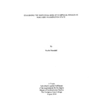
�t: --
mpic Coast National Marine Sanctuary l
and Observation Transect Lines
Llne1
- -
tfl•
~~-
Llne2
UneS ---------~~~-------------
"' .
--
Line4
~1ne5 ~--------------~~---
Llne7
Llne8 -
~
\
\
--....
~.
I•
:.:: \
LN11
Llne12
\
- r-------
\
Llne13 ·
Llne14
~
Rachol Stondo"l
T"• Evflg,.,n Stolo College
20U
l11l. C>U1191t, 011
.0. HO ...AIIOt.C, •lid
•tt••• UJ\tllb11t ~lf
Figure 1. The 14 main theoretical transect lines traveled during the shipboard surveys
between the years 1995-2008.
This study used 14 tracklines that ran east-west in direction, and were first
established in 1989 by the NOAA ship Miller Freeman. The tracklines were spaced at
9.26 km intervals. All 14 tracklines were surveyed each year between the years 19952000, except for the year 1999 when no surveys were conducted. ln 2002, only I 0 of the
tracklines were surveyed (the four most southern tracklines were not included because of
time restraints). In addition, in some years extra survey time allowed for a few replicate
surveys. In 1995, extra time allowed for replicate surveys ofthe northern transect lines.
The years 1996 and 2000 included a short offshore extension of two of the transect lines.
Three additional short east-west transect lines were added off southern Vancouver Island
29
�in the La Perouse Bank area in 1997. The year 2000 also included one additional line that
was surveyed south of the study area.
Each year, the ship surveys were conducted over a two-week period in late-June
and July (Table 1). In 2002, only a one week survey was conducted, mid-June. The
surveys were performed by a single marine mammal observer, located on the vessel's
sighting platform. The observer had a viewing height of 10 meters above the water level.
All surveys were conducted from the 55 meter NOAA vessel McArthur except for the
year 2000, when the 33 meter naval ship Agate Passage was used. From the sighting
platform, the observer scanned a 180-degree arc encompassing the area directly in front
of the ship and to both their right and left. When possible, the observers used a reticule
and obtained measurements of distance to the marine mammal sighting derived from the
angle below the horizon and the known platform height. Occasional sightings occurred
that could not be identified to the species level and were instead written down to the
general taxonomic level (e.g. unidentified cetacean) (Calambokidis et al., 2004).
30
�Table 1.
Summary of ship survey effort off Northern Washington (does not include small
boat surveys).
Year
Start
End
#of
le s
Ship
1995
21-Jul
27-Jul
10
McArthur
Troutman, Ellifrit
1996
28-Jun
5-Jul
14
McArthur
Troutman, Ellifrit
1997
9-Jul
18-Jul
17
McArthur
Troutman, Ellifrit
1998
25-Jun
4-Jul
14
McArthur
Troutman, Ellifrit
2000
16-Jun
24-Jun
14
Agate Passage
2002
12-Jun
18-Jun
10
McArthur
Troutman, Douglas
2004
23-May
31-May
14
McArthur II
Chandler, Douglas,
Huggins
Observers
Rowlett, Nelson
2005
5-Jun
6-Jul
8
McArthur II
Forney, Oedekoven,
Cotton, Salinas,
Feambach, Vasquez,
O'Toole
2007
30-Jun
9-Jul
14
McArthur II
Troutman, Douglas,
Rudd
2008
14-Jun
22-Jun
14
McArthur II
Bowlby, Douglas, Rudd,
Diehl, Rowlett
The collection of humpback data set B was also a collaboration between Cascadia
Research Collective and OCNMS. The surveys for the years 2004 and 2007 used the
NOAA vessel the RIV MacArthur II. In 2004, the surveys were conducted May 22-31.
The surveys for these years were conducted by six experienced observers, with three
31
�observers on watch at a time. Two of the observers used Fujinon 25x 150 binoculars
(known as "Bigeyes") and one central observer used 7x50 binoculars. The data entry was
conducted using a WINCRUZ program (Windows Real Time Sighting-Effort Event
Logger). Each observer spent 40 minutes rotating through each position then taking a
break for 2 hours. In 2005, the surveys were conducted June 4-13. Leg 1 of the cruise was
conducted aboard the NOAA ship McArthur. Legs 2-7 were conducted aboard the NOAA
ship David Starr Jordan. The year 2005 line transects were part of a larger survey effort
between the Southwest Fisheries Science Center and the National Marine Sanctuary
Program called CSCAPE (Collaborative Survey of Cetacean Abundance and the Pelagic
Ecosystem). Six experienced observers were involved, with three experienced observers
on effort at a time. Two observers used "Bigeyes" and one central observer used 7x50
binoculars. For data entry, the WINCRUZ program was used.
The 2007 survey dates were June 28-July 1oth and only one primary observer was
used. The observers used hand-held binoculars only. No "Bigeyes" binoculars were used
that year. All necessary data were entered into a sighting form and/or a computer. The
last year that the OCNMS line-survey data were collected was 2008. The procedure was
very similar to 2007. One experienced marine observer was observing at a time. The
observer used 7x50 binoculars with one additional person assisting with data entry (Final
Cruise Instructions (12 June 2007) M2-07-6)).
Mapping and Spatial Analysis
ESRI GIS software ArcMap version 10.2 was used for mapping the sanctuary, the
whale sightings and vessel densities. Analyses of the number of on-effort humpback
whale sightings per five nautical mile grids (9.26 km) were performed using a sum points
32
�in polygon function in Hawth's tools, an ecolo.gy toolbox extension created for ESRI
ArcGIS 9.I. The number of whales sighted per each grid cell per year was also calculated
using this same tool. These sighting rates and numbers of whales sighted were then
summed over all nine years and then the average for each individual cell was calculated.
These grid sizes were chosen because the transect lines were spaced five nautical miles
apart. The vessel density grids were created in ESRI ArcG IS I 0.2 using grid sizes of I
nautical mile (1.852 km) because the vessel densities per grid were much greater than the
whale densities and allowed the percentage of each category of vessel density to be
calculated in the larger grid cells.
A line intersects and summation tools were used in ArcGIS I 0.2 to calculate the
distance the vessel traveled in each individual grid cell per year. These line lengths were
then summed over all ten years and an average distance traveled per grid cell was
calculated. These line lengths per grid were then compared to the number of whale
sightings per year seen from that grid cell. The average number of on-effort whale
sightings per grid was also compared to the shipping density in the same grid cells for
both cargo and tanker vessels.
Marine mammal observation from predetermined boat transect lines is a common
method of estimating marine mammal population densities (Barlow, I995, Kishiro et al.
I997). However, there are many factors that influence whether a marine mammal will be
sighted during line survey observations. Marine mammals spend a considerable amount
of their lives submerged under the surface, which creates difficulty when estimating
population numbers using the number of individuals sighted at the surface. In any boat
line transect survey there is variation from the theoretical or predetermined transect lines
33
�and the actual transect lines that the boat travels. Attempts are made to minimize
deviations from these predetermined lines so that the lines can be replicated over time
and allow for easier comparisons between the data being collected (Buckland, 1987).
Many factors can influence when a boat is "on" or "off' effort. The vessel can go "offeffort" for a variety of reasons, including staffbreaks, changing personnel, weather
conditions, engaging in opportunistic sightings, boat maintenance, etc.
For this study "on-effort" is classified as when the boat is actively on the set
transect lines looking for humpback whales. Many effort calculations take into account
the weather conditions during the sightings; however, that is beyond the scope of this
study. Weather is accounted for somewhat in this study because the vessel would be
considered "off-effort" if the weather was deemed too poor for observations and all effort
that was labeled as "off-effort" was not included in this study (Figure 2).
34
�0 .:,
•
•
I#J~rnufi.P
Humpback Whale Sighting Locations
From Transect Lines in th e
Olympic Coast National Marine Sanctu ary
~
w
*$
"
•
1995-2002
-nk
•
"c--
/
·~
\
Legend
A
•
.
Humpback whales
.- - Transect lines
Cl OCNMS boundary
Rochol Sl~thl
Tho Evergrun Slolo College
201A
Figure 2. The number of"on-effort" humpback whales sighted from the 14 main transects
in the OCNMS during the years 1995-2002.
Humpback whales are a highly migratory species and are only present at the study
site during a few months of the year (Calambokidis et. al., 2004). Occasionally, a
humpback whale or other marine mammal is seen out of season or far from their usual
region (Douglas et al., 2008). The individual whales that are seen out of season or in
unusual geographic regions are usually sick or injured and shortly after their initial
sighting are found stranded onshore or floating dead nearshore (Cascadia Strandings and
Unusual Sightings, 2013 ). There have been increases in these unusual sightings of marine
mammals in the last several years (Huggins et al., 2011 ). Necropsies of these animals are
performed when possible to try and determine their cause of death. lt is possible that an
35
�increase in these unusual sightings could be a result of climate change altering weather
patterns and increasing water temperatures (Simmonds & Isaac, 2007).
Results
There were 518 on-effort whale sightings during the ten years of this study and 840 total
on-effort animals seen. The total number of whales sighted during the ten years was 1247
during 749 sightings including the off-effort sightings. Ofthe on-effort animals, 493 were
within the grid index, allowing us to compare their density patterns to the density patterns
of the vessel density in the area. The total number of cargo vessel points within the grid
was 66,013 and the total number of tanker vessel points within the grid was 53,593 for a
total of 119,613 shipping data points in the area during the year 2013.
The grid that was created for this analysis has 210 grid cells numbered 0-209. The
effort data were the number of sightings per grid cell per distance traveled in that grid
cell. These data were non-normally distributed. Regression analysis was used per year for
sightings per grid to highlight that more sightings occurred in grid cells that were more
heavily traveled. Each grid cell had a different amount of effort; however, we can see that
overall, the number of sightings were significantly positively correlated to the distance
traveled in that area (Figure 3). Areas with few or no whale sightings do not actually
indicate no whales in the area, only that little (or less) time was spent searching for
whales in that area. (1995 p= 0.0003, 1996 p=0.6567, 1997 p=0.051 0 1998, p=0.0021,
2000: p=O.OOOI, 2002 p=O.OOI, 2004: p=O.OOI, 2005: p=.1141, 2007: p=O.OOl, 2008:
p=O.OO I and all years combined p=O.OO 1).
36
�20
18
.:::
a,
161
14
liii
12
l£i
10
a..
;;;
.r::.
~
•
•
8
6
4
2
0
•
•
•
•
•
•
•
•
•••• •
•
•
•
••••
•
•
·-·..··
--··-···
•
•
•
•
•
•
•
.. •
•
•
•
T ...,....,.-.....- T . .,...
0 2000 4000 6000 8000
12000
1600{)
20000
Vess<el Distance Traveled
Figure 3. Bivariate fit of whales per grid by vessel distance traveled for all survey years
1995-2008 (p=<O.OO I).
A map was also created to show the number of whales per sighting as well as a
histogram showing the individual counts (Figure 4, Figure 5). All of the other maps show
sighting locations, not the actual numbers of whales seen in that location. This map helps
illustrate where the high numbers of whales were seen but also showcases that most
whale sightings were individuals or pairs (Figure 5). Only two sightings involved greater
than 10 individuals and the average number ofwhales per sighting was 1.63 (SD=1.16).
37
�300
286
250
200
.......
t:
5
u
150
100
50
0
tl I I
2
3
6
I
2
7
4
5
6
Number of Whales
8
4
I
12
14
Figure 4. The count of the actual number of humpback whales per individual sighting.
The average number of whales per sighting was 1.63 (SD=1 .16). There were 286
sightings where only one whale was seen and 171 sightings where only two whales were
seen.
38
�•
•
..
.
•
,.1J~~6J•l
&tr•
•
•
W
.£
..
..,..·. .:..,... .. .... . . . .'.. .
•••. ....•.....
.. <>·......
.. · ,•. •., :•.., .......,.. • . •• t-J
.!
..
..
·.:
··t
.........
... . ... ..,-,
.
.
.
...
,..,....... .
.
.
,_. ,... : ,•.'. ..
.
..
• •
. .J-..........
.
.
••
• . ··f
••••
•
.; . . ,., .
• •
•
. .•... -..•••.. . •
•
'\
, ...
•
:
.··· .
•
•
•
·~
......-'•
~
·,
,, t!'
'11
•
rl''
•
.1"
• •
,.
•
~
•
' ·
~' . . . . . .
..,.
•
.,..,,.
•
s
~~k"'
j• •
'-
..· "
•
•
• • • •• • • • • • • • • •
.~
\..t
•
'
I
•'~- , ' ,
•
~
..
.l. ...
•• ¥
•
~
,. • \ •
•
l
f
•
.. •
•
•
• •••
•tl
•
•
Number of Whales per Sighting
•
1
•
2
•
3
•
4
•
5
•
6
•
8
•
12
•
0
14
Sllneluary Boundary
•
\
••
•
•
., •.
•
,. •• •
•••
• •••
..
• ••
•
Rtcllel Stondthl
Tho Evtrg<ttn Stitt College
0 . hOM
t.o82 1~"d <W!41t Q)f'"VQ.tOrt
Figure 5. Map of the number of individual humpback whales per sighting off the Coast of
Northern Washington State from survey transects during the years 1995-2008.
A heat map was created using the point density tool in ArcGIS 10.2. This map
clearly shows the highest shipping density is at the entrance of the Strait of Juan de Fuca
to approximately 99 km offshore. This area of the shipping lane falls half inside the
sanctuary boundary. Another area of very high shipping density runs North to South and
runs almost directly through the middle of the northern half of the sanctuary (Figure 6).
39
�The greatest overlap of vessel and shipping traffic on this map is represented in blue and
is located approximately 22 kilometers from the opening of the Strait of Juan de Fuca
where the East-West shipping lane intersects the North-South shipping lane (Figure 6).
......
·£
s
.....
Lu.6J«tl•
t
·~
~,p<~-
.!'"' ,p~..,
~'
.('
ol>
II-
•
o~·o<f'' l~· o-f·o,,·"..~ ·".,.,.·".:-.,·"
I ~
I
I
iJ¥il
Figure 6. Heat map of non-effort corrected whale sighting locations during the years
1995-2008 overlaid on top of the heat map created for the number of total cargo and
tanker vessel points in the area during the year 2013.
40
�Calculating Encounter Rates
The vessel data and whale sightings per unit effort (SPUE) were used to estimate the
relative probability of an encounter between a vessel and whale. This is the relative
probability of a vessel and a whale occupying a given grid cell (Vanderlaan et al., 2008,
2009). These probability estimates are estimates as the SPUE and the AIS data do not
provide absolute numbers of whales or vessels per unit area. SPUE measures are based
on whales being observed at or near the surface. These encounter probability estimates
are 2-dimensional, meaning they are limited to surface encounters (Vanderlaan et al.,
2008).
The probability of a whale occupying any given grid-cell i relative to other cells
in a domain ofn cells (simplification of the 2-dimensional nx, y grid) was estimated using
the following formula (Vanderlaan et al., 2008):
Pre! (Whale);= SPDi
Lnn=I SPDi
In addition, the relative probability of a vessel occupying any given grid-cell i
relative to other cells in a domain of n cells, was calculated as:
Pre! (Vessel);= Vi
Lnn=I Vi
where Vi is the cumulative vessel number occupying grid-cell i (Vanderlaan et al., 2008).
These two equations where then used to calculate the relative probability of a vessel
encountering a whale within a given grid-cell i.
Pre! (Encounter); =freiCWhale)ixPreiCVessel)i
L n i=I(Prei(Whale)ixPrei(Vessel)i)
41
�Relative Probability of Observing a Whale or Vessel
Once the relative probabilities of an encounter between the whales and vessels
were calculated they were given a ranking between one and five. A ranking of five
indicates that that grid cell has the largest relative probability of an encounter in the study
area. I created a map showcasing these rankings on the grid that was created. The greatest
relative probability of sighting a humpback whale in the area, Prel(whale), occurs in the
highest SPUE areas (Figure 7).
42
�w•
1 0-8 OE·5
0 00010SMII·I 0
Wotld_Octan.Ba•
•
s
Racbtl Stondlhl
Ththcrsro.. Sto~oColloa•
2014
£ul C&.ortN Oe.&eO ••CAA t4GOC eno ottt. eot'tlt10 4lm
Figure 7. A grid overlaid on the study region with individual 5 nautical mile (9.26 km)
grid squares ranked based on the relative probability of an encounter between a whale
and a ship. The largest relative probabilities occur in the red grid cells. This map displays
the relative probability of an encounter between a humpback whale and a vessel using
sightings per unit effort.
43
�Relative Probability of a Whale and Vessel Encounter
The highest relative probability of a vessel-whale encounter is located in the
Northwestern corner of the grid, which reflects the fact that there is a high density of
ships in that area. This area is the main approach for vessels into the Strait of Juan de
Fuca. The relative probabilities of an encounter in the red areas of the map are
approximately five orders of magnitude larger than in the other parts ofthe study area
(Figure 7).
Non-effort corrected Relative Probabilities
When looking at the relative probability of a vessel-whale encounter based on the actual
locations of the whales and not the SPUE, the hotspots are located in similar areas on the
grid. However, there are fewer red grids and more diversity between the rankings. The
categories between the two maps have the same rankings in order to make easy
comparisons. There are also no results between l.0-8.0E-5 (Figure 8).
44
�NONE
W
. E
1 0-8 OE-8
2 0·9 OE·7
1 0·5 OE~
s
1 0-8 OE-5
Rachel S!tndohl
0 00001 ·1 0
Wolld_Octiiii_BIIt
The
0 4 75 9.S
.___ _ _ _ _ _ _ _ _ _ __ . ._ _ _ ,
I
J
I
I
.E''ffP'"' Suit Colltl t
lOU
19 Kilometers
I
I
I
J
iSH~ C4iL.CIUr•
G£8C.C .... ~, •40C
11\0 OIHr"CIY'&t·l:iU'«J
Figure 8. A grid overlaid on the study region with individual 5 nautical mile (9.26 km)
grid squares ranked based on the relative probability of an encounter between a w!'lale
and a ship. This map displays the relative probability of an encounter between a ship and
the non-effort corrected whale sighting locations. The largest relative probabilities occur
in the red grid cells.
45
�Discussion
When including all the humpback whale sightings in the study area without taking into
account any corrections for survey line effort it is clear that most of the whale sightings
occurred in the northern portion of the sanctuary and slightly north of the sanctuary's
border (Figure 8). When taking into account the amount of distance traveled in each grid
cell (effort) the highest area of intersect between whales and ships is also in the most
northern section of the sanctuary where the highest vessel traffic is entering the Strait of
Juan de Fuca to reach the ports inside of the greater Puget Sound region. The numbers of
ships in the area are only likely to increase in number but understanding where the
whales are located is the first step in decreasing overlap.
46
�•
Rachel Stendahl
The Evergreen State Colle ge
2014
•
Lilpt'fOli•O
!Jdnk
•
••
•
•
·-' •
•
• • • • :•i
•
•
s.wte"'
BllnS.
•
'.
•• •
~
•
•
•
:•,
•
-~
•
•
~
•
•
•• •
•
... •~··
.
...- . ••,.
.
.
•• •
•
••
• , ..• .
.
.
.
... . •••• .: .· .......
.
.
.
.t.:. •
.-. • J. . ... «.. "...
•
•
•••
..
....
~~jf •
•
••
••
•
• • ... • •
••
•
•
•
•
·~
-::--;-
I
t
I
il-
#
~ ,.,_:.!
~
• .,
~
d~- •
., •••--~ t". • • .... ••
•
•"
•• ~ t'
t~•t~
• •
••
•
-••
..,.....,.
••
•
•
-:-.
_ ...,_
~·
•
•
• •
•
•
••
t
I
t
I
l
I
-•·.-:.
•
•
,
I
• •
•
•
•
• •
•••••
•
•
•• •
•
I
•
•
•
•
•
•
•
All Whale Sighting Locations
•
Whale Slghtlngs
OCNMS Boundary
~---------------------------------------------~-- ·
•
•
••
.
• ••
•••
•
&fi. l> tt..o rrrtt, <+E &CQ, NOAA
•
w•
•
s
'
u ~c c . 1ntJ o tt~•'
cor,trtbvtore
Figure 9. The sighting locations of all humpback whales seen duri ng survey efforts 19952008.
47
�Significance of This Study
Humpback whales are an endangered species and as such they require extra protection.
Whaling has been outlawed in the United States and is no longer a major cause of
mortality, but whales continue to be challenged by anthropogenic sources of mortality
and stress (Douglas et al., 2008). Many of these other sources of mortality and stress,
such as underwater noise and pollution are much more difficult to pinpoint their exact
source making it is difficult to minimize these problems (Douglas et al., 2008). Ship
strike injuries and whale mortalities are easier to pinpoint the cause but the exact
magnitude of the problem is difficult to estimate. Nevertheless, it is apparent that it is an
important source of mortality, one that could be minimized with proper monitoring and
regulations (Redfern et al., 2011, Silber et al., 2012). Whales will only get hit by ships in
areas where their habitats and shipping traffic overlap. Research has shown that
minimizing the overlap between important whale habitats and shipping lanes can
considerably minimize this threat to vulnerable whale species and populations (Williams
& O'Hara, 20 I 0, Redfern et al., 2011 ).
Potential Mitigation Options
Rerouting shipping lanes in this area is a likely a viable option because there are definite
hotspots of humpback whale and ship interaction. Rerouting the shipping lanes to avoid
these hot spots would likely decrease interactions between humpback whales and ships.
Moving the vessel lanes has been shown to be an effective method in other areas of the
world (Tejedor et al., 2007, Berman-Kowalewski et al., 201 0). However, this study only
looked at the sighting locations of humpback whales in the region so there is a possibility
that moving the shipping lanes in the area would create a greater overlap of ships and
48
�other large whales that frequent the area, which would be similar to the findings in
Redfern e al. (2013). In addition the approach to the Strait of Juan de Fuca is fairly
narrow and the bathymetry and geography of the area is complex so it is not likely that
the lanes could be moved very far in some areas of this study region.
Reducing vessel speed has been shown to be the second most effective mitigation
procedure besides minimizing the spatial and temporal overlap between whale habitat
and vessel locations (Laist et al. 2001, Gende et al., 2011, Conn & Silber, 2013).
Although this method does not hinder an interaction between a whale and vessel it will
decrease the probability of a lethal encounter between the two (Vanderlaan et al., 2008).
This technique provides a very viable mitigation option for this area where there are not
many opportunities available for actually moving the lanes because of the narrow
entrance of the Strait of Juan de Fuca. A similar narrow hotspot of whales and ships is
located in the Strait of Gibraltar. This area successfully implemented speed
recommendations in a Traffic Separation Scheme (TSS) solely for the purpose of
conserving cetacean populations (Silber et al., 20 I 0).
Narrowing shipping lanes in locations where the lanes cannot be moved is another
potential mitigation option. If the vessels traveled in a more concentrated area there is
less overlap between the vessels and whale habitat. Narrowing the TSS by one nautical
mile in the Great South Channel of Massachusetts passing through critical northern right
whale habitat was shown to have potential conservation value although not as much as
moving the lane location completely (Merrick & Cole, 2007). The lanes off the Coast of
northern Washington State are already fairly narrow and with increased shipping traffic
in the future this option might not be the most feasible.
49
�Conclusion
The Olympic Coast National Marine Sanctuary and the surrounding waters have
high densities ofboth humpback whales and ships. This study provided a better
understanding of the spatial overlap of these whales and vessels. Relative encounter rates
between the whale sighting locations and vessels were calculated in order to see the likely
hotspots for interactions. These results showed that there are definite hotspots where
more whales are likely to be hit by ships. There are three main potential mitigation
procedures that are likely to be viable in this case, particularly rerouting the current
vessel lanes, narrowing the existing lanes and/or implementing vessel speed reductions in
the area.
50
�Chapter 3- Collaborative Management of the Sanctuary
Introduction
The Olympic Coast National Marine Sanctuary is the largest marine protected area in
Washington State. Marine protected areas have a difficult task of balancing many
different interests and activities. In general, marine protected areas have varying levels of
protection and effectiveness. The OCNMS is home to an unique A TBA that was
implemented in order to minimize oil spill threats to important wildlife as well as
maximizing vessel safety. The OCNMS has an extra difficult management plan because
it is home to the "Usual Accustomed Grounds" for several native tribes including Hoh,
Makah, Quileute tribes and the Quinault Indian Nation.
Marine Protected Areas
Washington State is home to many types of marine protected areas managed by a variety
of different stakeholders. The OCNMS is the largest marine protected area in the state
and the only one that is federally managed (Steelquist, 20 13). There is considerable
debate among scientists and conservationists about what types of sanctuaries are most
effective and how to manage all the conflicting interests within their waters (Hastings &
Botsford, 2003). Shipping is an extremely important industry in the region and cannot be
excluded from the area. Other economically important fisheries are located off the
northern coast of Washington including: salmon, halibut, tuna and shellfish. This region
also holds large cultural and historical significance to several local tribes in addition to
the Makah. Other tribes in the area include the Hoh, Makah, Quileute tribes and the
Quinault Indian Nation (Galasso, 2011).
51
�The OCNMS is home to few undeveloped shorelines left in North America, and it
is considered to have "exceptional opportunities" for scientific research and education.
The sanctuary is 1. 7 times larger than the entire Puget Sound and almost 2.5 times larger
than the Olympic National Park (Galasso, 2011 ). The sanctuary is truly unique because of
its size, location and collaborative management. The sanctuary has a stated goal of
promoting tourism, enhancing biological production and maintaining biodiversity. In
addition, The OCNMS Science Framework also requires the sanctuary to work
cooperatively with other institutions in conducting research (OCNMS Condition Report,
2008).
The Effectiveness of the Sanctuary
Large marine sanctuaries like OCNMS have proven to be more effective than small
sanctuaries in helping raise populations ofthreatened species (Murray & Ferguson,
1998). In most cases, very large sanctuaries such as OCNMS are more beneficial for fish
and invertebrates than marine mammals because the sanctuary encompasses all the
necessary habitats needed for all their life history phases. Marine sanctuaries have been
shown to be less effective for marine mammals that migrate long distances. Sanctuaries
have been shown to be especially effective in helping conserve groundfish and forage
fish populations because these species are less likely to leave the sanctuary (Addae,
2013). For cetaceans, sanctuaries have shown to be just one part of their conservation
measures and potential recovery because they often have to migrate through heavily
trafficked areas or other areas outside of the sanctuary where they are potentially more
exposed to other hazards (Mullen et al., 20 13).
52
�There are many types of marine sanctuaries and these sanctuaries can have
varying levels of protection. Many people are under the impression that the term
"sanctuary" means that no vessels are allowed in the area as well as no fishing or other
economic activities. However, this is usually not the case, there are very few sanctuaries
around the world that are complete "no- take" zones which means that there is absolutely
no harvesting of any species within the boundaries of the sanctuary (Murray & Ferguson,
1998). The OCNMS does have fishing and other economic activities taking place inside
the sanctuary boundaries (Galasso, 2011).
The OCNMS is home to an A TBA but it is not completely mandatory that all
vessels follow the recommendations (Figure 10). This particular A TBA is mainly focused
on reducing the threat of a catastrophic oil spill. The OCNMS has gone through several
revisions in their procedures, the most recent change was effective on December 1, 2012.
The latest change advises operators of vessels carrying oil or hazardous materials as
cargo, and all ships 400 gross tons and above, to maintain a 9.26 kilometer buffer from
the coast. There are some exceptions to this policy, some vessels greater than 400 gross
tons such as fishing vessels and research vessels have special permission to conduct these
activities primarily within the sanctuary boundaries. The ATBA is predominantly
targeted at large vessels that are transiting through the area in route to port (Galasso,
2011 ). Since 1998 the sanctuary has been closely monitoring vessel traffic through the
area. Non-complying vessels are tracked and targeted for additional outreach and
education on the importance of compliance. The response of the maritime industry has
been very favorable, with an estimated compliance rate of98.8 percent in 2007 (Vessel
Transits through OCNMS, 2014). Understanding the effectiveness of this particular
53
�A TBA and having a clearer picture of how this area is being used by the shipping
industry is an important first step for managing this area. This thesis focused exclusively
on tanker ships and cargo vessels, wh ich are the largest sh ips that are most likely to hit
whales. However, there are several well-documented cases from around the world of
whales being hit by other types of vessels including leisure boats, ferries, tug boats and
fishing vessels, among others (Laist et a t., 2001 ).
.,.
nr.-
..
.....
.,
.
'~~"•
INTERNAnoNAL MARmME ORGANIZAnON (IMO)
EA TO BE AVOIDED
OFF THE WASHINGTON COAST
'lft;ct•w O.C.m'* 1, 101:
...
J• ll!ft/r'ttt>tdll1.t ,..,,.k vt" _,.,. •~•..oily ~·"
•-t•
rr<ldmur /l(llNI/hll <tnd
'"'""~"'"'"'"""' i>j 1,
0/tllfPf< ,._, 1\dtWif<;/ AJufiM 1>4JklO~IJ '
0
....
_____. § b.........t.._ .
oil ''*'l't ai'UI !witt• tlwll ,..,~, llil 1ft"
haw,.... tmlk'tiuiJ "'MIA 11.1 to~t¥n
"',..,,.. """•'; 1111J eN Mlf' i
4</li ,.., • .,., tl4d .~... ~, '"
u • ..m~ '"" ""'"
fnll••••t ''"''llfAI<'ill f'W''"'""
/t/11111/ .....
~•li<J/oJ t~lilt"MIIIoiiJtW 1M
""". . ,...,..Jll1ll
WU'.Il'IIIWWMW
••
Q 41'2r,llll UA'44"AIW
0 41'2f',IM IU'U"MW
"0 WU'.II'II 124'1F11W
0
41"1t'.1tll nrii'MW
0 .,..,.,,... tW4r MW
0 .,..,.,,... tl4'11"tiW
Figure I 0. Map of Olympic Coast National Marine Sanctuary (in blue) and the Area To
Be A voided (in red). (Flyer: NOAA Olympic Coast National Marine Sanctuary).
54
�The OCNMS is home to the usual and accustomed areas of the Hoh, Makah,
Quileute tribes and the Quinault Indian Nation (Galasso, 2011 ). Treaty rights for the local
tribes were negotiated in the mid-1850s as part of the "Stevens Treaties" (Galasso, 2011 ).
The OCNMS's relationship with federally recognized tribes is unique within the National
Marine Sanctuary Program. The OCNMS must consider and protect the interests of the
tribe "to the fullest extent practicable in keeping with the purposes of the Sanctuary and
his or her fiduciary duties to the tribe" (15 CFR 922.153(c)) (Cooke & Galasso, N.D.).
The tribes depend on treaty rights to fishing in marine waters to sustain their cultures and
economies. These fisheries include salmon, groundfish and shellfish. The sanctuary has
been considering "no-take" areas that could potentially affect tribal members' livelihoods
and way of life. No take areas have been shown to be a particularly effective management
strategy and could be necessary when trying to conserve very endangered species
(Argady et al., 2003). There has been some controversy in the past between sanctuary
management and tribal rights, particularly on the issue of whaling rights.
The Makah tribe has been particularly vocal about their rights to whaling. They
began lobbying for a "cultural" exemption to the global ban on whaling in the mid-1990s.
In May 1999, the Makah hunted their first whale off the coast of Washington in over 70
years. This created a large controversy spurred on by the media between tribal right
supporters and animal rights groups. This controversy raised many questions about
whether the Makah should have the legal and moral right to resume hunting when they
conflict with the views of the majority ofthe non-Makah society and some animal rights
groups. There is evidence of the Makah hunting both humpback and gray whales as far
55
�back as 2,000 years ago. Traditionally, humpback whales were mostly used for
subsistence for tribal members. The International Whaling Commission (IWC) has
instituted a moratorium on commercial whaling since 1986. The gray whale was delisted
from the endangered species act in 1994 making the gray whale the preferred target for
continued Makah whale hunts. The Makah are the only Americans with a legal treaty
right to hunt whales making this issue inside the sanctuary particularly unique (Cooke &
Galasso, N.D., Erickson, 1999).
Formal Collaborative Bodies
There are two formal collaborative bodies that collaborate and coordinate regarding the
management decisions of OCNMS. These two councils are the Sanctuary Advisory
Council (SAC) and the Intergovernmental Policy Council (IPC). The sanctuary Advisory
Council has 21 members that provide stakeholder input from a large variety of
perspectives. This council includes seats for the four tribal groups, federal, state and local
agencies, local citizens, non-profit organizations and members of the public (Geiger et
al., 2012). The SAC has bimonthly meetings at various locations throughout the region.
The IPC is the first of its kind in the country. They have a stated goal of "Coordinating
policy, resources managers exchanging information and developing recommendations.
Protecting health and safety of coastal inhabitants" (Galasso, 2011 ). Both of these
collaborations are unique and allow the diverse interests and stakeholders of the area to
be heard.
56
�Conclusion
OCNMS is the largest marine sanctuary in Washington State and it is the only
sanctuary that is federally managed. There are many different stake holders involved in
the management of the sanctuary which is very unusual for a national sanctuary. In
addition, the sanctuary is home to the usual and accustomed areas of the Hoh, Makah,
Quileute tribes and the Quinault Indian Nation. Balancing the best known science in the
sanctuary with all of the private and tribal interests can be particularly challenging and is
not without conflict.
57
�Chapter 4-Costs
Introduction
There are many types of costs associated with collisions between whales and ships. Not
all of the "costs" involved in this issue are economic costs. The economic costs of this
issue are probably the most apparent to most people when they consider this problem but
there are other types of costs to consider as well. The economic costs could include costs
to the vessel companies caused by increased fuel consumption from having to travel
increased distances or by slowing their speed of travel. The economic costs also include
the cost of replacing boats or boat parts that are damaged by collisions with ships. It is
also important to consider the ethical costs and human costs of this issue as well. The
ship strike risk for humpback whales in Washington State is an important issue to
understand for a variety of reasons, including: ethical animal welfare concerns,
endangered species management, cultural significance ofthe whales to native tribes and
minimizing human injuries. These costs will be explored further below.
Economic Costs
Moving the shipping lanes in the OCNMS will have an economic cost. From an
economic standpoint, it is important to minimize the increased cost of transit by only
moving the ships the minimum distance needed to make a significant decrease in overlap
in high shipping density and high whale sighting density. From this perspective, it is
preferable to change the routes in a way that does not actually increase the overall
distance traveled so as to minimize the increased use of fuel. However, from a purely
environmental standpoint, requiring the vessels to make longer trips might increase the
vessel costs enough to affect what the United States ships to other countries. The United
58
�States is currently exporting many products such as coal to third world countries to bum
where there are fewer regulations.
Injuries and Costs to Humans from Ship Strikes
As humpbacks and other whales return to their traditional areas, run-ins with all
kinds of boaters will increase. Humpback whales are baleen whales meaning that they do
not echolocate and can surface very unexpectedly. Collisions between boats and whales
can be very dangerous to humans. A breaching whale collided with a boat near
Vancouver Island in 2013, cracking the hull of the boat and sending the driver through
the windshield. The injuries that he sustained required surgery (Lavoie, 20 13). There
have been several recorded cases around the world where ship strikes have caused
significant injuries to humans onboard and in a few cases even resulted in the death of the
passenger. Small fast moving boats such as whale watching vessels and passenger ferries
that collide with whales are more likely to experience injures to passengers on board
(Laist et a!., 2001 ). There have been reports of passengers being knocked off their feet or
even thrown from boats when their boat collides with a whale. Andre et a!. (1997) in
Laist et a!. (200 I) reported a case in the Canary Islands in which a passenger ferry
collided with a sperm whale, killing both a passenger and the sperm whale (Jensen &
Silber, 2003).
In addition to injuries or deaths of both whales and humans, whale boat collisions
can have large economic tolls. Vessels colliding with whales can result in serious damage
to the boat that can be very costly to fix. Many of the ships reporting damage from
collisions with whales cite damaged propellers and propeller shafts, damaged rudders and
cracked hulls (Jensen & Silber, 2003). One report states that an eight meter recreational
59
�Bayliner sustained a cracked hull when it collided with a humpback whale outside of
Juneau, Alaska. In addition, there have been several reports of naval vessels in California
sustaining severe damage to the vessels after colliding with unknown species of whales
(Jensen & Silber, 2003).
Animal Welfare Perspective
Collisions between whales and boats also have an ethical animal welfare perspective.
Cases where the whale was suffering for days before dying have been recorded (Neilson
eta!., 2012). In 2003, there was an injured humpback whale that was seen alive in
southeastern Alaska with a deformed head and a severely inflated tongue that was likely
due to the blunt force trauma of a ship strike (the whale was spotted alive for three days
before dying) (Neilson eta!., 2012). In December 2010, a whale stranded in Washington
State with severe injuries. The whale had been sighted in southern Puget Sound for
several weeks with a very visible and deep injury to its dorsal area that may have
occurred up to several months previously. Upon closer inspection the whale was
determined to be a Bryde's whale, an endangered species that is mostly found in tropical
waters. The collision had sheared off the top portion of at least two of the dorsal
processes ofthe animal (Huggins eta!., 2011).
Reports of severely injured whales raise ethical questions about whether human
intervention is required. It is especially difficult when it seems obvious that the whale is
in a lot of pain and appears to be suffering. However, the logistics of euthanizing a whale
or otherwise ending its misery are very complex. Dosing enough of the correct chemicals
to be fatal to the whale can be extremely difficult to determine and using a gun to shoot
the animal could potentially just add to the suffering of the animal (Huggins eta!., 2011).
60
�The drugs used in euthanasia would render the body of the whale toxic and would require
extra measures for proper disposal. If the whale was euthanized and not disposed of
quickly enough, the carcass could poison scavengers such as the birds and coyotes that
feed offofit (Huggins et al., 2011).
Ship strikes that appear non-lethal can eventually prove lethal and likely reduce
fitness through numerous health consequences. These can include hemorrhaging and
secondary infections, stress-induced immunity impairment and hampered movements
resulting in decreased foraging efficiency predator avoidance and reproductive success
(Camargo & Bellini, 2007).
Conclusion
The ship strike issue in Washington State can be viewed from many different
perspectives highlighting its interdisciplinary nature. In addition to the potential
conservation biology costs associated with diminishing the population of an endangered
species, there are economic costs associated with vessel and whale collisions. These
economic costs range from increased fuel consumption by rerouting the shipping lanes to
damage to a vessel sustained from a collision. The animal welfare perspective of this
issue is also worth discussing, many of these animals are suffering before they die which
has a large ethical component.
61
�Chapter 5: Future Directions/Limitations to this Study
Introduction
This study is the first attempt to examine the ship strike issue in Washington State. It
solely focuses on the OCNMS which is only a small portion of the waters ofthe region.
The area has very high shipping traffic coupled with high concentrations of whales and
other important species so it is a great starting place for examining this complex issue. To
continue to monitor this issue it would be beneficial to examine the ship strike concern in
other parts of Washington State as well. Ship transect surveys are an effective way of
observing whales but adding photo-identification observations and data taken from
opportunistic sightings would make the results more robust.
This thesis is an analysis using some of the available data collected during the line
transects surveys in the years 1995-2008. These humpback whale sightings do not
include four of the years in this 13 year study. There are holes in the data for the years
1999, 2001, 2003 and 2006. It is likely that the sighting information for those years is
similar to the years that were collected but is impossible to predict for sure. Ten years of
survey information is a good start but humpback whale sighting locations for additional
years will provide an even more accurate picture of where whales are located within the
sanctuary's boundaries.
When possible during this study, photographs of the individual humpback whales
spotted were taken. The photographs were a part of capture-recapture techniques that for
humpback whales focus on their scars, natural markings and pigmentation to uniquely
identify individuals. This technique relies on getting clear photographs of the dorsal side
of the fluke of these whales, entering them into a large database and then matching the
62
�different photographs between years. This process is very time-consuming but effective
in tracking the movements of individuals and populations (Calambokidis & Barlow,
2004). These photo-identification methods coupled with the line transect survey methods
can paint a clearer understanding of the humpback whale populations in the area. Many
of the same individuals are able to be identified year after year traveling to the same
locations with other individuals showing close associations between group members. In
addition to genetic information, these unique patterns in associations and movements can
lend insight into distinct populations that deserve special protections and conservation
measures (Calambokidis et al., 2004).
This analysis uses individual sightings ofhumpback whales; each sighting is
counted as one sighting regardless of whether there were multiple humpback whales
together making up that one sighting. Sometimes a single sighting would contain a
mother and calf pair or other individuals up to four. The actual "best" number of
individuals seen was recorded in the database but was not used in this analysis. The
"best" sighting number was the observer's very best estimate of the number of individual
whales present. Recorded on the initial data sheet was also a "low" estimate ofthe
number of whales sighted, meaning the very minimum number of whales it could be and
a "high" estimate of the number ofwhales sighted. The majority ofwhales sighted were
individuals (286/513 56%). These exact numbers of whales present are helpful to know
when interpreting the results because an individual sighting with many animals present
may indicate a location that is more important than areas that only include sightings of
single humpback whales (Table 2).
63
�Table 2. Summary of both on and off effort humpback whale sightings from line transect
surveys in the Olympic Coast National Marine Sanctuary conducted during the years
1995-2008.
Year
# Sightings
#of Animals
# sightings
#of Animals
#Sightings
#of Animals
1995
1996
1997
1998
2000
2002
2004
2005
2007
20
23
18
20
22
31
37
33
28
47
122
5
7
2
8
10
25
54
23
48
24
40
31
5
9
49
11
7
33
27
48
45
210
8
59
61
73
104
392
79
116
116
120
144
749
2008
Total
72
83
89
72
99
518
158
142
102
140
840
86
44
36
57
130
217
218
175
244
1247
Many whales show distinct avoidance behavior to nearby vessels. Humpback
whales and other whale species have displayed changes in surfacing patterns and duration
of traveling underwater, as well as observed changes in swimming speeds and horizontal
and vertical change in swimming direction (Richardson et al., 1995). In southwest
Alaska, humpback whales have been observed showing two main vessel avoidance
strategies: 1. whales seem to avoid vessels by traveling horizontally at distances over 2
km from ships; and 2. Whales avoid the ships by moving vertically when vessels are
within 2 km (Richardson et al., 1995). Studies on other species of whales have
demonstrated that whales can show avoidance behavior from boats at distances of over 4
km (Richardson et al., 1995); however, differences in the approach angle of either the
vessel or the whale can result in changes in the avoidance behavior.
64
�There are many types of vessels that use the waters of Washington State. Many
ship strike reports categorize vessels into the following categories: private recreational,
non-motorized recreational (e.g., kayaks and canoes), commercial recreational (e.g.
charter vessels, tour boats and commercial whale watch vessels), cruise ship, cargo (e.g.,
oil tankers, container ships, and landing craft), commercial fishing, research, USCG
cutter, state ferry, or unknown (Neilson et al., 20 12). Occasionally vessel types are
categorized by length, including small (<15m), medium (15-79m), large (2:80 m) or
unknown (Neilsen et al., 2012). This analysis focuses exclusively on the large tanker and
cargo ships that travel through this area. These large ships are much less maneuverable
and not as likely to see whales in their path as smaller vessels. In addition, these large
vessels are more likely to cause fatal injuries to the whales (Laist et al. 2001 ).
In studies conducted in the waters of Maui County, Hawaii, sub-adult humpback
whales and calves appear more susceptible to ship strikes. These young whales represent
about 68% of known ship strike reports (Lammers et al., 2003). All whale watching
vessels in Maui are small passenger vessels, 65 feet or less in length, with low tonnage
(most under 20 tons) and are not classified as "ships" (Laist et al., 2001 ). These smaller
vessels were not the focus of this study but can have a potential impact. Whales that
become habituated to these smaller vessels constantly around them are less likely to
realize the potential danger of the larger and less maneuverable ships in the area. There
have been many studies conducted around the world focusing on these smaller ships,
especially whale watching boats and high speed passenger vessels (Panigada et al., 2006,
201 O)(Carrillo & Ritter, 201 0). In this region studies have been conducted on interactions
65
�between whales and small vessels but these studies have almost exclusively focused on
the resident killer whale population (Bain et al., 2006).
Other Conservation Concerns in the Sanctuary
There are several other conservation concerns in the OCNMS in addition to ship strike
risk. The monitoring of the humpback whales and other marine mammals in the sanctuary
will also help aid understanding of other conservation concerns including the use of naval
sonar. In 2003, the United States Navy proposed a significant expansion of their
underwater tracking range that could potentially cause acoustic damage to the marine
mammals that are in the area. The data that were collected and used for this study on the
times and locations of humpback whales in the area are part of a much larger monitoring
program that also includes marine birds. The information that was gathered for these
surveys will serve a variety of important conservation purposes (Calambokidis et al.,
2004, Steelquist, 2013).
Other issues facing the OCNMS include derelict fishing gear and marine debris,
climate change, invasive species, commercial development, and oil spills. In 2005, the
sanctuary was awarded funding from NOAA's Marine Debris Program for a pilot project
identifying and removing derelict fishing gear in the northern parts of the sanctuary. This
pilot program was a partnership with the Makah tribe. So far, only the nearshore waters
near Cape Flattery have been surveyed by sonar and divers looking for these hazards.
Several abandoned fishing nets and crab pots were recovered; however, the extent of the
problem over such a great area is unknown. NOAA provided additional funding in 2007
to support collaborative development of long-term strategies to remove the accumulated
marine debris from the beaches of the sanctuary. Partner agencies have formed an
66
�organization called Washington Clean Coast Alliance to coordinate public outreach of
this issue and plan beach clean-up events. The alliance held their first event in 2008
coinciding with Earth Day. Over 1,100 volunteers helped clean the beaches and
successfully removed almost 23 tons of debris (Gallaso, 2011 ).
NOAA has conducted research on the biggest threats facing the OCNMS. The
NOAA site analysis that was completed indicated it was necessary to increase research
on fishing/harvesting effects, zoning, living marine resources, and
restoration/rehabilitation in the sanctuary. The report also noted that water quality
protection and industrial uses were other areas that required further study.
Three National Wildlife refuges lie within the sanctuary boundaries. These
refuges are collectively called the Washington Island National Wildlife Refuges and are
part ofthe Washington Maritime National Wildlife Refuge Complex and protects over
600 named and unnamed offshore rocks, seastacks and islands (OCNMS Condition
Report, 2008).
Status reports on the state ofthe resources in the OCNMS are compiled every five
years. Overall, the resources protected by the sanctuary have been giving rating of good
to fair condition which is likely due to the area being isolated from major urban and
industrial areas. The National Marine Sanctuary System began a system wide monitoring
program in 2001. This System Wide Monitoring (SWiM) program is designed to
facilitate "the development of effective ecosystem-based monitoring programs that
address management information needs using a design process that can be applied in a
consistent way at multiple spatial scales and to multiple resource types" (OCNMS
Condition Report, 2008).
67
�Future Uses for These Data
The humpback whale data compiled for this report have never been previously used for
examining ship strike risk in the area. However, the data from this study for the years
1995-2002 were previously analyzed for a report on marine mammal populations in the
sanctuary (Calambokidis et al., 2004). The last four years of these data, 2004, 2005, 2007
and 2008 were not previously compiled or used in any publications. The data entry and
compilation work that was completed for this project will be beneficial for future studies
that will include these same data. This study focused on spatial analysis of the ship-strike
issue. In the future, the data will probably be analyzed in greater depth using modeling
techniques similar to the methods used by Redfern et al., (2011 ).
The database containing the whale sighting locations from the 14 main transects
used in this analysis also included opportunistic and small boat sightings that were
discarded for this initial analysis. Information from other sources, tribes, and
opportunistic sightings are also available within the OCNMS. These sighting data from
off the transect lines and from these other sources could be analyzed in the future and add
additional insight into this important issue.
Conclusion
There are many possible ways of analyzing both the shipping data and the whale sighting
location data. Analyzing the data using a different measure of "effort" could potentially
change the outcomes of this study. The actual rate of humpback whale mortalities are
very difficult to predict, and is beyond the scope of this study. In addition to vessels
striking whales, there are considerable other conservation concerns facing the sanctuary.
These other conservation concerns include naval sonar usage, marine debris and
68
�entanglements. OCNMS is working in collaboration with several other organizations to
address these issues.
Moving forward, there are additional opportunistic humpback whale sighting data
in the sanctuary from these same transect lines, as well as sightings collected from tribal
and other sources. It would be beneficial if the next study was able to compare these
opportunistic and other sources of sighting data to the data used for this analysis.
69
�Appendix
To understand vessel transits the staff at OCNMS kept track of twenty vessel
types shown in Table 3 ("Vessel Transits Through Olympic Coast National Marine
Sanctuary", 2014). The included density maps used six vessel classes, meaning some of
the initial vessel types were combined into larger categories to include all of the vessels
that transited the outer coast of Washington that have a Satellite Automatic Identification
System (S-AIS) transponder (Table 3). For this analysis, only the data included in the
vessel classes of tanker and cargo were used ("Vessel Transits Through ... ", 2014).
Table 3. The types of vessels traveling through the study area during the year 2013 and
the vessel classes that they were categorized into for mapping and analysis purposes.
2012-2013 Vessel Tn~es
Bulk Carrier
Cable Layer
Cargo Ship
Chemical Carrier
Container Ship
Dredger
Drill Ship
Fishing Vessel
Liquefied Gas Carrier
Oil Tanker
Passenger Ships
Pollution Control
Private Vessel
Public Vessels
Refrigerated Cargo
Research Ship
RoRo Cargo Ship
Supply Ship
Tug
Vehicle Carrier
Vessel Class
Cargo
Misc.
Cargo
Tanker
Cargo
Misc.
Misc.
Fishing
Tanker
Tanker
Passenger
Misc.
Misc.
Misc.
Cargo
Misc.
Cargo
Misc.
Tug
Cargo
70
�S-AIS data are collected as points along a vessel transit. The S-AIS data gather
various information about the vessel's identity, location and a date and time stamp so that
their movements can be monitored ("Vessel Transits Through ... ", 2014). This method
has some discrepancies because the numbers of points that are captured during vessel
transit are related to the number of satellites that capture the AIS signal from the vessel's
transponder which is also affected by the speed of the vessel as it travels through the area
of interest ("Vessel Transits Through ... ", 2014). The density maps were divided into 1
km 2 grid cells. The number of unique vessel transits which were represented by
individual S-AIS points were counted for each grid. The sanctuary categorized the data
into three categories representing a relative measure oflow, medium and heavy traffic
areas (Figure 9, Figure 10). There are advantages and disadvantages of displaying the
data this way. One advantage is that each class contains an equal number of grids; there
are no empty classes or classes with too few or too many grids ("Vessel Transits
Through ... ", 2014).
71
�Cargo Ship Use of WA Outer Coast - 2013
Figure 11. Cargo Ship Use of Washington Outer Coast during 2013. Map by NOAA staff
Nancy Wright.
72
�Tanker Use of WA Outer Coast - 20 13
· 20
Figure 12. Tanker ship usage ofthe Washington Outer Coast in 2013. Map by NOAA
staffNancy Wright.
73
�In this type of map, it is easy to see the patterns for the areas that are considered
heavy in vessel traffic. However, it is possible to see the limitations of using the
intermittent and sometimes infrequent S-AIS data as the only source of transit
information about the vessels in the area ("Vessel Transits Through ... ", 2014). In the
maps, you can see that some vessel transits have "holes" caused by the occasional grid
that does not have a recorded data point. A clearer picture of the actual transit patterns
could be created with additional satellite coverage or the use of terrestrial AIS stations.
These additional sources of data would be especially useful in representing transits in
lower density areas ("Vessel Transits Through ... ", 2014).
74
�Works Cited
Addae, K. 2013. The effects of marine reserves on regional groundfish diversity within
the San Juan Archipelago, Washington. Masters Thesis. Evergreen State College.
Agardy, T., Bridgewater, P., Crosby, M.P., Day, J., Dayton, P. K., Kenchington,R.,
Laffoley, D., McConney P., Murray, P.A., Parks, J. E. and Peau, L. (2003).
Dangerous targets? Unresolved issues and ideological clashes around marine
protected areas. Aquatic Conservation: Marine and Freshwater Ecosystems, 13:
353-367.
Andre, M., M. Terada, andY. Watanabe. 1997. Sperm whale (Physeter macrocephalus)
behavioural response after the playback of artificial sounds. Rep. Int. Whal.
Commn 47:499-504.
Bain, D. E., J. C. Smith, R. William, and D. Lusseau. 2006. Effects ofvessels on
behavior of Southern Resident killer whales (Orcinus spp.). NMFS Contract
Report No. AB 133F03SE0950 and AB 133F04CN0040. 61 pages.
Barlow, J. 1995. The abundance of cetaceans in California waters. Part I: Ship surveys in
summer and fall of 1991. Fishery Bulletin, U.S. 93:1-14.
Barlow, J., Calambokidis, J., Baker, C. S., Burdin, A.M., Clapham, P. J., Ford, J. K. B.,
Gabriele, C. M., & LeDuc, R. (2011). Humpback whale abundance in the North
Pacific estimated by photographic capture-recapture with bias correction from
simulation studies. Marine Mammal Science, 27(4), 793-818.
Berman-Kowalewski, M., Gulland, F. M.D., Wilkin, S., Calambokidis, J., Mate, B.,
Cordaro, F. M. D., Gulland, J ., & Rotstein, D. (20 10). Association between blue
whale (Balaenoptera musculus) mortality and ship strikes along the California
coast. Aquatic Mammals, 36(1 ), 59-66.
Buckland, S. T. 1987. Estimation ofminke whale numbers from the 1984/85 IWC/
IDCR Antarctic sighting data. Report ofthe International Whaling Commission
37:263-268.
Buckland, S. T., Cattanach, K. L., & Lens, S. (1992). Fin whale abundance in the eastern
North Atlantic, estimated from Spanish NASS-89 data. Report of the
International Whaling Commission, 42, 457-460.
Calambokidis, J ., & Steiger, G. (1990). Sightings and movements of humpback whales in
Puget Sound, Washington. Northwestern Naturalist, 71, 45-49.
Calambokidis, J., Steiger, G. H., Straley, J. M., Herman, L. M., Cerchio, S., Salden, D.
R., Balcomb, K. C. (19). (200 1) Movements and population structure of
humpback whales in the North Pacific. Mar Mamm Sci, 17, 769-794.
Calambokidis, J., T. Chandler, L. Schlender, K. Rasmussen, and G.H.
Steiger. 2002. Research on humpback and blue whales off California, Oregon,
and Washington in 2001. Final report to Southwest Fisheries Science Center, La
Jolla, CA. Cascadia Research, 218Y2 W Fourth Ave., Olympia,
WA 98501. 50pp.
Calambokidis, J. and J. Barlow. 2004. Abundance ofblue and humpback whales in the
eastern North Pacific estimated by capture-recapture and line-transect
methods. Marine Mammal Science 20(1 ):63-85.
75
�Calambokidis, J., G.H. Steiger, O.K. Ellifrit, B.L. Troutman and C.E. Bowlby.
2004. Distribution and abundance of humpback whales and other marine mammals
off the northern Washington coast. Fisheries Bulletin 102(4):563-580.
Calambokidis, J., Falcone, E. A., Quinn, T. J., Burdin, A.M., Clapham, P. J., Ford, J. K.
B., ... Rojas-Bracho, L. (2008). SPLASH: Structure of populations, levels of
abundance and status of humpback whales in the North Pacific. Unpublished
report submitted by Cascadia Research Collective to USDOC, Seattle, WA under
contract AB133F-03-RP-0078 [available from the author]. Retrieved from
http://www.cascadiaresearch.org/SPLASH/SPLASH-contract-Report-May08.pdf
Calambokidis, J. (2011). Ship strikes ofwhales offthe U.S. west coast. American
Cetacean Society, 1-7.
Calambokids, J. (2013) New Development Dealing with Ship Strikes of Whales offthe
U.S. West Coast. American Cetacean Society, 1-5.
Campbell-Malone, R., S. G. Barco, P. Y. Daoust, A. R. Knowlton, W. A. McLellan, D. S.
Rotstein, and M. J. Moore. 2008. Gross and histological evidence of sharp and
blunt trauma in North Atlantic right whales (Eubalaena glacialis) killed by
vessels. Journal of Zoo and Wildlife Medicine 39:37-55.
Camargo, F.C. & Bellini, C. (2007). Report on the collision between a spinner dolphin
and a boat in the Fernando de Noronha Archipelago, Western Equatorial Atlantic,
Brazil. Biota Neotropica 7(1), 209-211.
Carrillo, M., & Ritter, F. (2010). Increasing numbers of ship strikes in the Canary Islands:
proposals for immediate action to reduce risk of vessel-whale collisions. Journal
of Cetacean Research Management, 11 (2), 131-138.
Cascadia stranding response and unusual sightings. (2013, June 13). Retrieved from
http://www.cascadiaresearch.org/Strandings.htm
Conn, P. B., and G. K. Silber. 2013. Vessel speed restrictions reduce risk of collisionrelated mortality for North Atlantic right whales. Ecosphere 4(4):43.
Cooke V., Galasso, G. N.D. Challenges and opportunities for the Makah tribe and
Olympic Coast National Marine Sanctuary. 186-190.
Czech B, Krausman PR. The Endangered Species Act: history, conservation biology, and
public policy. Baltimore: The John Hopkins University Press; 2001.
Darling, J.D. 1984. Gray whales off Vancouver Island, British Columbia. pp. 267-87. In:
M.L. Jones, S.L. Swartz and S. Leatherwood (eds.) The Gray Whale, Eschrichtius
robustus. Academic Press, Orlando, Florida. xxiv+600pp.
Department of Transportation, U.S. Coast Guard. Port Access Routes Study; Strait of
Juan de Fuca and Adjacent Waters. 1999. Notices. Federal Register. Vol. 64
No.12.
Douglas, A. B., Calambokidis, J., Raverty, S., Jeffries, S. J., Lambourn, D. M., &
Norman, S. A. (2008). Incidence of ship strikes of large whales in Washington
State. Journal of the Marine Biological Association of the United Kingdom, 88( 6),
1121-1132.
Erbe C. (2002). Underwater noise of whale-watching boats and potential effects on killer
whales (Orcinus orca), based on an acoustic impact model. Marine Mammal
Science. 18:394-418.
Erikson, P. P. (1999), A-whaling we will go: encounters ofknowledge and memory at the
Makah Cultural and Research Center. Cultural Anthropology, 14: 556-583.
76
�Endangered Species Act. 1973; amended 2002, p. 219-65, United States.
Felix, F. and Van Waerebeek, K. (2005) Whale mortality from ship strikes in Ecuador
and West Africa. Latin American Journal ofAquatic Mammals 4(1 ): 55-60.
Galasso, George. 2000. Olympic Coast National Marine Sanctuary Area to be A voided
(ATBA) Education and Monitoring Program. Marine Sanctuaries Conservation
Series MSD-00-1. U.S. Department of Commerce, National Oceanic and
Atmospheric Administration, Marine Sanctuaries Division, Silver Spring, MD. 35
pp.
Galasso, G. Office of National Marine Sanctuaries. 2011. Olympic Coast National
Marine Sanctuary Final Management Plan and Environmental Assessment. U.S.
Department of Commerce, National Oceanic and Atmospheric Administration,
Office ofNational Marine Sanctuaries, Silver Spring, MD. 352 pp.
Geiger, K., Gershman, D., Roberts, E., & Wenger, M. (2012). An Assessment of
Institutional Relationships at the Olympic Coast National Marine Sanctuary.
Master's Thesis. University of Michigan School of Natural Resources and
Environment. Pp. 1-222.
Gende, S.M., Hendrix, A.N., Harris, K.R., Eichenlaub, B., Nielsen, J. and Pyare, S. 2011.
A Bayesian approach for understanding the role of ship speed in whale-ship
encounters. Ecol. Appl. 21 (6): 2,232-40.
Harris, K., Gende, S., Logsdon, M., & Klinger, T. (2012). Spatial Pattern Analysis of
Cruise Ship-Humpback Whale Interactions in and Near Glacier Bay National
Park, Alaska. Environmental Management, 49(1 ), 44-54.
Hastings A., Botsford, L.W. (2003) Comparing Designs of Marine Reserves for Fisheries
and for Biodiversity. Ecological Applications. 2003 13:spl, 65-70
Jensen, A.S. and G.K. Silber. 2003. Large Whale Ship Strike Database. U.S. Department
ofCommerce, NOAA Technical Memorandum. NMFS-OPR-, 37 pp.
Huggins, J., J. Calambokidis, D. Lambourn, B. Diehl, J. Oliver, S. Jeffries, and S.
Raverty. 2011. Tropical cetaceans in southern Puget Sound: anomalous sightings
and strandings in Washington State, 2010-2011. Abstract (Proceedings)
19th Biennial Conference on the Biology ofMarine Mammals, Tampa, Florida,
November 27-December 2, 2011.
Kishiro, T., H. Kato, T. Miyashita, I. Ishii, T. Nakajima AND E. SHINOHARA. 1997.
Abundance ofBryde's whales offKochi, estimated from the 1994/95 and 1995/
96 sighting surveys. Report ofthe International Whaling Commission 47:
575-581.
Klinowska, M. (1991 ). Dolphins, porpoises, and whales of the world: the IVCN red data
book. IUCN. Gland, Switzerland and Cambridge, UK.
Laist, D. W., Knowlton, A. R., Mead, J. G., Collet, A. S. and Podesta, M. (2001),
Collisions between ships and whales. Marine Mammal Science, 17: 35-75.
Lammers M.O., Pack A.A. and Davis L. (2007) Trends in whale/vessel collisions.in
Hawaiian waters. Available from Oceanwide Science Institute. 31 pp.
Lavoie, J. (20 13, May 17). Campbell River man undergoes facial surgery after breaching
humpback whale collides with boat Http://www.timescolonist.com/news/local/campbell-river-man-undergoes-facialsurgery-after-breaching-humpback-whale-collides-with-boat1.191360#sthash.QtQN42Qi.dpuf.Times Colonist. Retrieved April15, 2014.
77
�LeDuc, R. G., Weller, D. W., Hyde, J., Burdin, A.M., Rosel, P. E., Brownell, R. L., ... &
Dizon, A. E. (2002). Genetic differences between western and eastern North
Pacific gray whales (Eschrichtius robustus). Journal of Cetacean Research and
Management, 4(1 ), 1-6.
Magden, R. (2008, April 18). Port ofTacoma --Thumbnail History. Retrieved May 15,
2014, from
http://www.historylink.org/index.cfm?DisplayPage=output.cfm&file id=8592
Merrick RL, Cole TVN. 2007. Evaluation ofNorthern Right Whale Ship Strike
Reduction Measures in the Great South Channel of Massachusetts. NOAA Tech
Memo NMFS NE 202; 12 p.
Morgan, M.A. and Patton, G.W. (1990) Human Dolphin interactions on the West Coast
ofFlorida: Documentation from MML's Marine Mammal Response Program.
Mote Marine Laboratory Technical Report 191. 9pp.
Mullen, K.A., Peterson, M.L., & Todd, S.K. (20 13). Has designating and protecting
critical habitat had an impact on endangered North Atlantic right whale ship strike
mortality?.Marine Policy, 42293-304.
Murray, MR and Ferguson L. 1998. The status of marine protected areas. Proceedings of
the Puget Sound Research Conference, Seattle, WA. Puget Sound Water Quality
Action Team. 1998 pp. 783-793.
Neilson J.L., Gabriele, C.M., Jensen, A.S., Jackson, K. and Straley, J.M., Summary of
reported whale-vessel collisions in Alaskan waters, Journal of Marine Biology,
vol. 2012, Article ID 106282, 18 pages, (2012). doi:10.1155/2012/106282.
Norman, S.A., Bowlby, C.E., Brancato, M.S., Calambokidis, J.,Duffield, D., Gearin, P.J.,
Gornall, T.A., Gosho, M.E., Hanson,B., Hodder, J., Jeffries, S.J., Lagerquist, B.,
Lambourn, D.M.,Mate, B., Norberg, B.,Osborne, R.W., Rash, J.A., Riemer, S.
Scordino, J. (2004) Cetacean Strandings in Oregon and Washington between 1930
and 2002. Journal of Cetacean Research and Management 6(1 ): 87-99.
Nowacek, D. P., Johnson, M. P., Tyack, P. L., Shorter, K. A., McLellan, W. A. & Pabst,
D. A. 2001. Buoyant balaenids: The ups and downs of buoyancy in right whales.
Proceedings: Biological Sciences. Royal Society. London. B268, 1811-1816.
Nowacek, D.P., Johnson, M.P., & Tyack, P. L. 2004. North Atlantic right whales
(Eubalaena glacialis) ignore ships but respond to alerting stimuli. Proceedings:
Biological Sciences, 2 71 ( 1536), 227-231.
Office of National Marine Sanctuaries. 2008. Olympic Coast National Marine Sanctuary
Condition Report 2008. U.S. Department of Commerce, National Oceanic and
Atmospheric Administration, Office ofNational Marine Sanctuaries, Silver
Spring, MD. 72 pp.
Pace, R. M. (200 1). Frequency of whale and vessel collisions on the US eastern
seaboard: ten years prior and two years post ship strike rule. US Department of
Commerce, National Oceanic and Atmospheric Administration, National Marine
Fisheries Service, Northeast Fisheries Science Center. Retrieved from
http://www.nefsc.noaa.gov/nefsc/publications/crd/crd 1115/crd 1115.pdf
Pace, R.M. III, Silber, G., 2005. Simple analysis of ship and large whale collisions: does
speed kill? Poster paper. In: The 16th Biennial Conference on the Biology of
Marine Mammals, Society for Marine Mammalogy, San Diego, CA, December
12-16.
78
�Panigada, S., Pesante, G., Zanardelli, M., Capoulade, F., Gannier, A., & Weinrich, M. T.
(2006). Mediterranean fin whales at risk from fatal ship strikes. Marine Pollution
Bulletin, 52(2006), 1287-1298.
Pluta P.J. (2002) Traffic separation schemes: in the Strait of Juan de Fuca and its
approaches; in Puget Sound and its approaches; and in Haro Strait, Boundary
Pass, and the Strait of Georgia. United States Environmental Protection Agency.
FR Document 02-217785. Billing code 4910-15-P.
http://www.epa.gov/fedrgstr/EPA-IMPACT/2002/August/Day-27 /i21785 .htm
L., Becker, E. A., & Barlow, J. (2011). Assessing the risk of ships striking large whales
in marine spatial planning. Conservation Biology, 27(2),
Reeves, R., Rosa, C., George, J. C., Sheffield, G., & Moore, M. (2012). Implications of
Arctic industrial growth and strategies to mitigate future vessel and fishing gear
impacts on bowhead whales. Marine policy, 36(2), 454-462.
Rice, D. W. (1974). Whales and whale research in the eastern North Pacific. The whale
problem: A status report. Harvard Press, Cambridge, MA, 170-195.
Rice, D.W. 1978. The humpback whale in the North Pacific: Distribution, exploitation,
and numbers. Pages 29-44 inK. S. Norris and R. R. Reeves, eds. Report on a
workshop on problems related to humpback whales (Megaptera novaeangliae) in
Hawaii. U.S. Department of Commerce, National Technical Information Services
PB280794, Springfield, VA.
Richardson, W .J ., Greene, C. R., Mal me, C. I. & Thompson, D.H. (1995). Marine
Mammals and Noise. San Diego, CA: Academic.
Shelden, K.E. W., D. J. Rugh J. L. Laake J.M. Waite, P.J. Gearin, and T.R. Wahl. 2000.
Winter observations of cetaceans off the northern Washington coast.
Northwestern Naturalist 81: 54-59.
Silber, G., Gerrior, P. and Zoodsma, B. (2004) NOAA's Fisheries proposed strategy to
reduce ship strikes of North Atlantic right whales- Shipping Industry dialog.
[Available at http://www.nero.noaa.gov/shipstrike]
Silber, G. K., Slutsky, J., & Bettridge, S. (2010). Hydrodynamics of a ship/whale
collision. Journal of Experimental Marine Biology and Ecology, 391 (20 10), 1019.
Silber, G. K., Vanderlaan, A. S.M., Arceredillo, A. T., Johnson, L., Taggart, C. T.,
Brown, M. W., & Bettridge, S. (2012). The role ofthe international maritime
organization in reducing vessel threat to whales: process, options, action and
effectiveness. Marine Policy, 36(20 12), 1221-1233.
Simmonds, M.P., & Isaac, S.J. (2007) The impacts of climate change on marine
mammals: early signs of significant problems. Oryx, 41, pp 19-26.
Steelquist, R. (2013, January 30). Olympic Coast National Marine Sanctuary. Retrieved
from http://olympiccoast.noaa.gov/living/welcome.html
Taylor, B.L., Baird, R., Barlow, J., Dawson, S.M., Ford, J., Mead, J.G., Notarbartolo di
Sciara, G., Wade, P. & Pitman, R.L. (2008). Physeter macrocephalus. In: IUCN
2008. IUCN Red List of Threatened Species.
Tejedor, A., R. Sagarminaga, A. Can-adas, R. de Stephanis, and J. Pantoja. 2007.
Modifications of maritime traffic off southern Spain. International
Whaling Commission document SC/59/BC13.
79
�Vanderlaan, A. S.M. and Taggart, C. T. (2007), Vessel collisions with whales: the
probability oflethal injury based in vessel speed. Marine Mammal Science,
23: 144-156.
Vanderlaan, A. S., Taggart, C. T., Serdynska, A. R., Kenney, R. D., & Brown, M. W.
(2008). Reducing the risk of lethal encounters: vessels and right whales in the Bay
of Fundy and on the Scotian Shelf. Endangered Species Research,4 (3), 283.
Vanderlaan, A. S., Corbett, J. J., Green, S. L., Callahan, J. A., Wang, C., Kenney, R. D.,
... & Firestone, J. (2009). Probability and mitigation ofvessel encounters with
North Atlantic right whales. Endangered Species Research,6(3), 273-285.
Vanderlaan, A. S.M., & Taggart, C. T. (2009). Efficacy of a voluntary area to be avoided
to reduce risk oflethal vessel strikes to endangered whales. Conservation Biology,
23(6), 1467-1474.
Van Waerebeek, K., Baker, A.N., Felix, F., Iniguez, M., Sanino, G.P., Secchi, E.,
Slocum, G., Sutaria, D., Van Heiden, A. Wang, Y. (2005) Vessel collisions with
small cetaceans worldwide and with large whales in the Southern Hemisphere:
building a standardized database. Paper SC/58/BC6 presented to the IWC
Scientific Committee, St Kitts, May-June
2005. [Available from the IWC Secretariat, Cambridge, UK].
Van Waerebeek, K., Baker, A., Felix, F., Gedamke, J., Iniguez, M., Sanino, G., Secchi,
E., Sutaria, D., van Heiden, A., & Wang, Y. (2007). Vessel collisions with small
cetaceans worldwide and with large whales in the Southern Hemisphere, an initial
assessment. Latin American Journal Of Aquatic Mammals, 6(1), 43-69.
doi:http://dx.doi.org/1 0.5597 /lajamOO 109
Vessel Transits Through Olympic Coast National Marine Sanctuary. (2014, April 16).
Retrieved May 5, 2014, from
http://olympiccoast.noaa.gov /protect/incidentresponse/20 13 ais.pdf
Visser, I.N. (1999) Propeller scars on, and known home range oftwo Orca (Orcinus
orca) in New Zealand waters. New Zealand Journal of Marine and Freshwater
Research 33: 635-642.
Webb, R.L. 1988. On the Northwest, Commercial Whaling in the Pacific Northwest
1790-1967. University of British Columbia Press,Vancouver. xxi+425pp.
Weinrich, M. (1998). Early experience in habitat choice by humpback whales
(Megaptera novaeangliae ). American Society of Mammologists, 79( 1), 163-170.
Weller, D. W., Klimek, A., Bradford, A. L., Calambokidis, J., Lang, A. R., Gisborne, B.,
... & Brownell, R. L. (20 12). Movements of gray whales between the western and
eastern North Pacific. Endangered Species Research, 18(3), 193-199.
Whitehead, H. (2002). "Sperm whale Physeter macrocephalus". In Perrin, W., Wiirsig B.
and Thewissen, J. Encyclopedia of Marine Mammals. Academic Press. pp. 11651172. ISBN 0-12-551340-2.
Wiley D.N., Asnutis R.A., Pitchford T.D. And Gannon D.P. (1995) Stranding and
mortality of humpback whales, Megaptera novaeangliae, in mid-Atlantic and
Southeast United States 1985-1992. Fishery Bulletin 93, 19-205.
Wiley, D. N., Thompson, M., Pace, R. M., & Levenson, J. (2011). Modeling speed
restrictions to mitigate lethal collisions between ships and whales in the
Stellwagen Bank National Marine Sanctuary, USA. Biological Conservation,
144(2011), 2377-2388.
80
�Williams, R., Lusseau, D., & Hammond, P. S. (2006). Estimating relative energetic costs
of human disturbance to killer whales (Orcinus orca). Biological
Conservation, 133, 301-311.
Williams, R., Bain, D. E., Smith, J. C., & Lusseau, D. (2009). Effects ofvesse1s on
behaviour patterns of individual southern resident killer whales Orcinus
orca.Endangered Species Research, 6(3), 199-209.
Williams, R., & O'Hara, P. (2009). Modelling ship strike risk to fin, humpback and killer
whales in British Columbia, Canada. Journal of Cetacean Research and
Management, 11, 1-10.
81